Góra
Góra | |
|---|---|
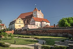
 Saint Catherine's Church | |
| Coordinates: 51°40′N 16°33′E / 51.667°N 16.550°E | |
| Country | |
| Voivodeship | Lower Silesian |
| County | Góra County |
| Gmina | Gmina Góra |
| Government | |
| • Mayor | Irena Krzyszkiewicz |
| Area | |
| • Total | 13.65 km2 (5.27 sq mi) |
| Population (2006) | |
| • Total | 12,574 |
| • Density | 920/km2 (2,400/sq mi) |
| Postal code | 56-200 |
| Vehicle registration | DGR |
| Website | http://www.gora.com.pl |
Góra [ˈɡura] (German: Guhrau) is a town in Lower Silesian Voivodeship, in south-western Poland. It is the administrative seat both of Góra County and of the smaller district (gmina) called Gmina Góra.
Geography
The town is located within the historic Lower Silesia region, approximately 69 kilometres (43 mi) north-west of the regional capital Wrocław. As at 2006, it has a population of 12,574.
History
The settlement in the Duchy of Silesia was first mentioned as Gora in an 1155 deed by Pope Adrian IV conveying the property to the Diocese of Wrocław. The name of the town means "hill" or "mountain" in Old Polish. In 1288 it became part of the Duchy of Głogów under the Piast duke Henry III and received Magdeburg rights. The German name Guhrau is first documented in 1336. From the 14th century onwards, the town developed to a centre of cloth manufacturing.
Guhrau was annexed by Prussia upon the First Silesian War in 1742 and from 1816 was the administrative seat of Landkreis Guhrau within the Province of Silesia. Again a county seat from 1946, from 1975 to 1998 Góra belonged to Leszno Voivodeship.
International relations
Góra is twinned with:
Notable people
- Ludwik Mateusz Dembowski (1768-1812), general and traveler
- Werner Naumann (1909-1982), Nazi secretary of state
- Radosław Kałużny (born 1974), football player
External links
- Official website
- Jewish Community in Góra on Virtual Shtetl
- Guhrau Gora Pictures
- Góra Pictures


