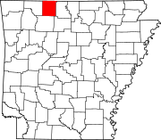
Gaither Township, Boone County, Arkansas
Appearance
Gaither Township | |
|---|---|
| Coordinates: 36°8′52.77″N 93°9′27.68″W / 36.1479917°N 93.1576889°W | |
| Country | |
| State | |
| County | Boone |
| Area | |
• Total | 21.005 sq mi (54.40 km2) |
| • Land | 20.991 sq mi (54.37 km2) |
| • Water | 0.014 sq mi (0.04 km2) |
| Population (2010) | |
• Total | 676 |
| • Density | 32.20/sq mi (12.43/km2) |
| Time zone | UTC-6 (CST) |
| • Summer (DST) | UTC-5 (CDT) |
| Zip Code | 72601 (Harrison) |
| Area code | 870 |
Gaither Township is one of twenty current townships in Boone County, Arkansas, USA.[1] As of the 2010 census, its total population was 676.
Geography
According to the United States Census Bureau, Gaither Township covers an area of 21.005 square miles (54.40 km2); 20.991 square miles (54.37 km2) of land and 0.014 square miles (0.036 km2) of water.
Population history
Populations before 1870 cover the time when this area was part of Carroll County.
| Census | Pop. | Note | %± |
|---|---|---|---|
| 1840 | 425 | — | |
| 1850 | 508 | 19.5% | |
| 1860 | 972 | 91.3% | |
| 1870 | 955 | −1.7% | |
| 1880 | 1,788 | 87.2% | |
| 1890 | 2,942 | 64.5% | |
| 1900 | 523 | −82.2% | |
| 1910 | 453 | −13.4% | |
| 1920 | 336 | −25.8% | |
| 1930 | 254 | −24.4% | |
| 1940 | 253 | −0.4% | |
| 1950 | 228 | −9.9% | |
| 1980 | 592 | — | |
| 1990 | 653 | 10.3% | |
| 2000 | 717 | 9.8% | |
| 2010 | 676 | −5.7% |
References
- United States Census Bureau 2008 TIGER/Line Shapefiles
- United States Board on Geographic Names (GNIS)
- United States National Atlas
- ^ "Gaither Township, Boone County, Arkansas." U.S. Census Bureau. Breakdown. Retrieved June 2, 2012.
External links


