General Taboada Department
Appearance
General Taboada Department | |
|---|---|
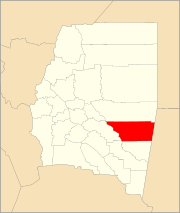
 Location of General Taboada Department within Santiago del Estero Province | |
| Coordinates: 28°27′36″S 62°50′2″W / 28.46000°S 62.83389°W | |
| Country | |
| Province | Santiago del Estero |
| Head town | Añatuya |
| Area | |
| • Total | 6,040 km2 (2,330 sq mi) |
| Population (2010) | |
| • Total | 38,105 |
| • Density | 6.3/km2 (16/sq mi) |
| Time zone | UTC-3 (ART) |
General Taboada Department (Spanish: Departamento General Taboada) is a department of Argentina in Santiago del Estero Province. The capital city of the department is situated in Añatuya.
