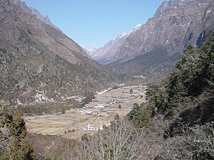
Ghunsa
Appearance
Ghunsa
घुन्सा | |
|---|---|
Village | |
 Ghunsa Village | |
| Coordinates: 27°39′40″N 87°56′10″E / 27.66111°N 87.93611°E | |
| Country | |
| Development Region | Eastern |
| Zone | Mechi Zone |
| District | Taplejung District |
| Government | |
| • Type | VDC |
| Time zone | UTC+5:45 (Nepal Time) |
| Post code | 32907 |
Gunsha is a village of Taplejung, Nepal at elevation of 3475m and is a major check point for Mt. Kangchenjunga. This village came into attention after the helicopter accident that killed 24 passengers including most prominent figures in conservation work.[1]
Inhabitants
The area is a Sherpa village who are involved in subsistence farming and yak grazing. The main crops are maize and potatoes.
Access
The village can be accessed from Taplejung in 3 days walk along the bank of Tamur River. The trail passes though numerous waterfalls and rivulets making it favorite among the trekkers all around the world.
Facilities
- Hotels : There are few hotels that serves for the tourist and local travelers.
- Health post :There is one health post in this village
- Education :The Ghunsa community is currently served by a six government staffed school that was built with the support of a group of climbers from San Francisco.
- Microhydro :A 35 kw microhydro has been constructed and is under operation. Water from Ghunsa river is used to run the turbines of this plant. The energy has served to reduce local deforestation and also helped to flourish tourism in neighboring village.

