Gibralfaro
| Gibralfaro | |
|---|---|
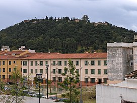
 View of Gibralfaro with the castle on top | |
| Highest point | |
| Elevation | 130 m (430 ft) |
| Geography | |
| Parent range | Montes de Málaga |
| Geology | |
| Mountain type | Limestone |
| Climbing | |
| Easiest route | From Málaga |
Mount Gibralfaro, Template:Lang-es, is a hill located in Málaga in southeast Spain. It is a 130 m high foothill of the Montes de Málaga, part of the Cordillera Penibética.[1]
At the top of the hill there is a castle overlooking Málaga city and the Mediterranean Sea.
History
Gibralfaro has been the site of fortifications since the Phoenician foundation of Málaga city. At the beginning of the 14th century, Yusuf I of the Kingdom of Granada constructed on its top the eponymous castle within the Phoenician enclosure. The name is said to be derived from the Phoenician word for light, Jbel-Faro, meaning "Rock of Light".
At the end of 2005, a thick forest of pines and eucalyptus trees were planted on the hill. On its outskirts are the historical buildings of the seminary and the Alcazaba, the Jardines de Puerta Oscura (Dark Gate Gardens), as well as a Parador.[2]
Currently pending approval is a project intended to safeguard the mount and its surroundings from any urban intervention and promote it as a space for public recreation. Another project is planned to build a cable car linking the city center with the Gibralfaro castle.[3]
Geology
Gibralfaro is part of the southern foothills of the Montes de Málaga, a mountain range of the Cordillera Penibética, formed of materials from the Maláguide complex of the Baetic Cordillera.
References
- ^ Plan Especial de Protección del Monte Gibralfaro - Ayuntamiento de Málaga
- ^ Conocer España por la ruta de los paradores, Ediciones Gaesa, page 90
- ^ Impulso al plan para proteger el Monte Gibralfaro y potenciar su uso cultural - Málaga Hoy
- This article incorporates information from the equivalent article on the Spanish Wikipedia

