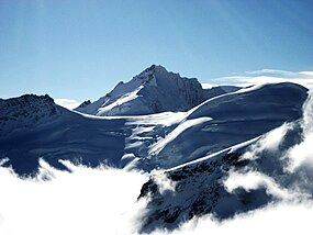
Gletscherhorn
Appearance
| Gletscherhorn | |
|---|---|
 The Gletscherhorn (background) from the Jungfraujoch (north side) | |
| Highest point | |
| Elevation | 3,983 m (13,068 ft) |
| Prominence | 346 m (1,135 ft)[1] |
| Parent peak | Jungfrau |
| Listing | Alpine mountains above 3000 m |
| Coordinates | 46°30′46″N 7°58′04″E / 46.51278°N 7.96778°E |
| Geography | |
| Location | Bern/Valais, Switzerland |
| Parent range | Bernese Alps |
The Gletscherhorn (3,983 m) is a mountain of the Bernese Alps, located on the border between the Swiss cantons of Bern and Valais. It forms the eastern edge of the Lauterbrunnen Wall, south of the Jungfrau.
See also
References
External links

