
Golddust, Tennessee
Golddust, Tennessee | |
|---|---|
 | |
 Location in the State of Tennessee | |
| Country | United States |
| State | Tennessee |
| Counties | Lauderdale |
| Time zone | UTC-6 (CST) |
| • Summer (DST) | UTC-5 (CDT) |
| ZIP code | 38063 (Ripley, Tennessee)[2] |
Golddust is a rural unincorporated community in Lauderdale County, Tennessee, located on the banks of the Mississippi River. Golddust is one of the earliest settlements in Lauderdale County.
In 1864, the Battle of Fort Pillow was fought about 3 mi (4,8 km) south of Golddust.
Geography
Golddust is located at 35.72540 North, 89.85870 West. The elevation above sea level is 248 ft (75.6 m).[3]
Island No. 30 of the Mississippi River is located ca. 2.5 mi (4 km) west of Golddust. The landscape of the area is dominated by the Mississippi River valley, flood plains and cotton fields. Most dwellings in the area are built on stilts to withstand floods.
Golddust is situated on the southeastern edge of the New Madrid Seismic Zone, an area with a high earthquake risk.
History
Establishment 1820s
Golddust was founded in the 1820s. It is one of the earliest settlements in Lauderdale County.[4]
Battle of Fort Pillow 1864
In 1861, the Confederate States Army built extensive fortifications south of Golddust and named the site for General Gideon J. Pillow. Because of its strategic location, the fort was taken by the Union Army in 1864.
Fort Pillow State Park is located ca. 3 mi (4,8 km) south of Golddust.
Economy

Agriculture is the chief source of income in the area surrounding Golddust, especially the cultivation of cotton.
After the abolition of slavery, sharecropping was the primary means of income for low income families in the area. Mostly for the cultivation of cotton, land would be used by sharecroppers in return for a share of the crop to the landowner.
Modern machines such as the cotton picker have made manual cultivation obsolete over time as they took over the work from hand laborers.
As of 2007, there were no industries in Golddust. Dwellings are scattered, some of them abandoned, and the borders of the community are unmarked.
Infrastructure
Tennessee State Route 19 starts at the Mississippi River in Golddust, heading east through Ripley (Lauderdale County), Nutbush and Brownsville (both in Haywood County) to Interstate 40.[5]
See also
References
- ^ U.S. Geological Survey Geographic Names Information System: Golddust, Tennessee
- ^ http://www.downloadzipcode.com/ DownloadZIPcode
- ^ http://wayhoo.com/index.php?a=wlist&sr=20&state=TN&map=Golddust WayHoo.com Geographic coordinates
- ^ http://tennesseeencyclopedia.net/imagegallery.php?EntryID=L010 Tennessee Encyclopedia of History and Culture
- ^ http://www.tdot.state.tn.us/Maps/county/co49.pdf Lauderdale County, TN Highway Map
Municipalities and communities of Lauderdale County, Tennessee, United States | ||
|---|---|---|
| City | 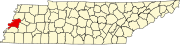 | |
| Towns | ||
| Unincorporated communities | ||