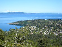
Gordon Head

Gordon Head is a seaside neighbourhood in the Greater Victoria municipality of Saanich. Gordon Head lies north of McKenzie Avenue and east of the Blenkinsop Valley. The University of Victoria is located partly within Gordon Head along the southeast boundary. Finnerty Road separates Gordon Head from the adjacent neighbourhood of Cadboro Bay. The local area is dominated physically by Mt. Douglas, a coastline along Haro Strait, and the central plateau.
History
For 4,000 years the Songhees people inhabited the lands between Sooke and the Saanich Peninsula, which includes Gordon Head.[1]
In 1852, with the signing of the Douglas Treaties, farmers began settling the hitherto densely forested Gordon Head area. By 1860, 13 men, including Michael Finnerty and John Work, owned all of the land. The region would become famous for its strawberries and later its daffodils. City water service was introduced in 1921, leading to a proliferation of greenhouses and vegetable farming. Agriculture dominated the landscape until about the 1950s, when Gordon Head began gradually developing into a residential neighbourhood.[2]
During WWII, a Special Wireless Station was established at Gordon Head in June 1940. It played a significant role in the Royal Canadian Navy's radio intelligence operation against the Japanese. Messages were intercepted here and bearings on enemy transmissions were provided using direction finding techniques. The station closed in 1946; however, the building that housed the station still stands in a remote corner of the University of Victoria, having been moved from its original location.[3]
Today, many homes in Gordon Head have secondary suites in order to both improve housing affordability and meet the housing demands of the local student population.[4][5]
Name
The neighbourhood shares its name with the small strip of land that juts out into Haro Strait, east of Margaret Bay, in the community's north-east corner. Gordon Head is named after Admiral John Gordon, who in 1845 commanded the HMS America in the North Pacific.[6][7]
Parks
Gordon Head has 27 parks ranging in size from the minuscule Balmacarra Park (671 square metres) to the magnificent Mount Douglas Park (181 hectares), the largest park in Saanich.
Several parks offer beach access. The half-rocky, half-sandy beach located between Arbutus Cove Park and Hollydene Park is Gordon Head's most frequented beach.
Schools
Six schools belonging to the Greater Victoria School District (SD 61) call the community home:
Elementary
Middle
Secondary
Maria Montessori Academy is the only independent school in Gordon Head.
Gordon Head Recreation Centre
GHRC is centrally located and features a pool, sauna, steamroom, whirlpool, weightroom, dance and fitness studio, as well as a skateboard/rollerblade park.
Recent eco-friendly updates to the centre include UV pool filtration (in addition to the existing chlorine-based system) and solar-powered showers.
Retail locations
- Torquay Village
- Tuscany Village
- University Heights Shopping Centre
Pedestrian shortcuts
Sprinkled across the community are dozens of pedestrian shortcuts. (The adjacent neighbourhoods of Cadboro Bay and Cordova Bay have relatively few shortcuts by comparison.)
A map showing the shortcuts (in dotted red) is available on OpenStreetMap.
References
- ^ "Songhees Nation | Lkwungen People". songheesnation.com. Retrieved 2014-06-27.
- ^ "Gordon Head" (PDF). Saanich Heritage Register. 21 July 2008. Retrieved 2014-06-09.
- ^ Murray, Gil (2001). The Invisible War: The Untold Secret Story of Number One Canadian Special Wireless Group, Royal Signal Corps, 1944-1946. Toronto: Dundurn. p. 22. ISBN 9781550023718.
- ^ "Saanich urged to allow secondary suites north of McKenzie". Victoria Times Colonist. Retrieved 2016-02-06.
- ^ "UVic planning for additional student housing". Victoria Times Colonist. Retrieved 2016-02-06.
- ^ "The Province of British Columbia - GeoBC". apps.gov.bc.ca. Retrieved 2014-06-09.
- ^ "Biography – GORDON, JOHN (1792-1869) – Volume IX (1861-1870) – Dictionary of Canadian Biography". biographi.ca. Retrieved 2014-06-09.
