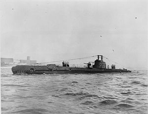
HMS Safari
 HMS Safari
| |
| History | |
|---|---|
| Name | HMS Safari |
| Builder | Cammell Laird & Co Limited, Birkenhead |
| Laid down | 5 June 1940 |
| Launched | 18 November 1941 |
| Commissioned | 14 March 1942 |
| Honours and awards | Sicily 1943, Mediterranean 1943 |
| Fate | Sold to be broken up for scrap; sunk on tow to shipbreakers 8 January 1946 |
| Badge |  |
| General characteristics | |
| Displacement |
|
| Length | 217 ft (66 m) |
| Beam | 23 ft 6 in (7.16 m) |
| Draught | 11 ft (3.4 m) |
| Speed |
|
| Complement | 48 officers and men |
| Armament |
|
HMS Safari, launched in November 1941, was one of the third group of British S-class submarines built by Cammell Laird & Co Limited, Birkenhead. So far she has been the only ship to bear the name Safari.
Safari was sponsored by the citizens of Dereham, Norfolk - the sum of £250,339 being raised during a "Warship Week".
Career
She spent most of World War II in the Mediterranean Sea where she was highly successful. She sank:
- The Italian sailing vessels Adda, Ausonia, Eufrasia, Eleonora Rosa, Stefano M., and Nasello
- The Italian merchants Perseo, Torquato Gennari, Valsavoia, Loredan, Entella, Isonzo, Peppino Palomba and Salemi
- The German transport Hans Arp
- The Italian ships Bice, Aniello, Sogliola and Gemma
- The German barge F 346
- The Italian auxiliary minesweepers Rosina S., No. 295/Bella Italia, No. 47/Amalia, FR 70/La Coubre and R 106 /Onda
- The Italian fishing vessel S. Francesco di Paola A.
- The Italian tanker Isonzo
- The German transport ship KT-12
- The German barges Maria and Paula
- The Italian armed yacht Margherita
- The Italian pilot vessel F 50/Silvio Onorato
- The Italian minelayer Durazzo
Safari also damaged the following:
- The Italian merchants Tigrai, Eneo, and Liv (the former Norwegian Liv)
- An unknown sailing vessel
- The Italian merchant Veglia (the former Yugoslavian Kosovo). The damaged ship was later salvaged but declared a total loss
- The Italian auxiliary patrol vessel F 139 / Constantina. The damaged Italian ship was declared a total loss.
- Attacked two and sunk one unidentified German transports which were unloading equipment on a North African beach, one torpedo that missed its mark continued up the beach and destroyed a tank.
Safari also launched unsuccessful attacks on the Italian merchant Cap Figalo and the German controlled French tanker Champagne. Safari also attacked the Italian submarine Bronzo.
On 19 October 1942 HMS Unbroken had torpedoed and damaged the Italian merchant Titania. The Titania was taken in tow by the Italian destroyer Ascari, but was sunk early the next day by Safari.[1]
On 8 January 1946 she was being towed to the breaker's yard to be scrapped when she sank in heavy seas with no crew on board. Today she is a popular site for divers in the English Channel, she lies on a rock seabed at a depth of 44 m. Her conning tower has been removed, as has the nose cone, so the bow caps (outer doors of the torpedo tubes) are visible.
HMS Safari was commanded for much of her wartime career by Benjamin Bryant, who also commanded HMS Sealion during the war. Bryant later recounted his exploits aboard the two vessels in his book, One Man Band (later republished as Submarine Commander). Safari is also the subject of the book Crash Dive by Arthur Dickison, who served under Bryant.
References
- ^ HMS Safari, Uboat.net
- Colledge, J. J.; Warlow, Ben (2006) [1969]. Ships of the Royal Navy: The Complete Record of all Fighting Ships of the Royal Navy (Rev. ed.). London: Chatham Publishing. ISBN 978-1-86176-281-8.
