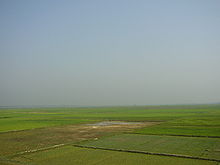
Hakaluki Haor


Hakaluki Haor (Bengali: হাকালুকি হাওর, Sylheti: ꠀꠇꠣꠟꠥꠇꠤ ꠀꠅꠞ) is a marsh wetland ecological system of North-Eastern Bangladesh.[1] It is one of Bangladesh's largest and one of Asia's larger marsh wetland resources. A total of 558 species of animals and birds have been identified here, including some very rare – already declared as threatened, vulnerable, endangered and critically endangered species. Some 190,000 people live in the surrounding Hakaluki haor area.[2]
Hakaluki Haor was designated an Ecologically Critical Area (ECA). It also is a protected Ramsar site[3] of international importance for the conservation and sustainable utilization of wetlands.
The surface area of Hakaluki Haor is 181.15 km2, of which 72.46 km2 (40.01%) is within the territory of Barlekha Upazila. It is also under Kulaura Juri upazila of Moulvibazar District and Golapganj, Fenchuganj upazila of Sylhet district.[1]
See also
References
- ^ a b Nixon Talukder and Sanzida Murshed, "Hakaluki Haor", Banglapedia
- ^ "Ecologically Critical Area", M. Aminul Islam, Banglapedia
- ^ Jamal Anwar, "Migratory and other Birds in Bangladesh in Danger"
