Hartismere Hundred
Appearance
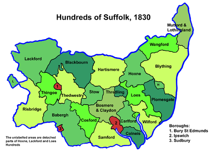
Hartismere was a hundred of Suffolk, that later gave its name to a poor law union, a rural sanitary district, and the Hartismere Rural District.
Listed as Hertesmere in the Domesday Book, the name of the hundred is derived from "Hart's mere" where Hart is a personal name.[1]
Hartismere also gives its name to the 11-19 Co-educational Foundation School based in Eye. It serves pupils aged 11–16 years whilst the associated sixth form college instructs 16-19 year students. The School is distinctive in having particularly close links to the Hartismere Community. It is also the name of a hospital and maternity unit at Eye.
Parishes

Hartismere Hundred consisted of the following 32 parishes:[2][3]
| Parish | Area (acres) |
|---|---|
| Aspall | 827 |
| Bacton | 2231 |
| Botesdale | 1260 |
| Braiseworth | 722 |
| Brome | 893 |
| Burgate | 2034 |
| Cotton | 1922 |
| Eye | 4174 |
| Finningham | 1235 |
| Gislingham | 2251 |
| Mellis | 1344 |
| Mendlesham | 3880 |
| Oakley | 1280 |
| Occold | 1480 |
| Palgrave | 1475 |
| Redgrave | 2059 |
| Redlingfield | 1075 |
| Rickinghall | 1401 |
| Rishangles | 719 |
| Stoke Ash | 1173 |
| Stuston | 798 |
| Thorndon | 2680 |
| Thornham Magna | 1327 |
| Thornham Parva | 670 |
| Thrandeston | 1379 |
| Thwaite | 832 |
| Westhorpe | 1322 |
| Wetheringsett-cum-Brockford | 3777 |
| Wickham Skeith | 1770 |
| Wortham | 2727 |
| Wyverstone | 1523 |
| Yaxley | 1239 |
References
- ^ Walter Skeat (1913). The Place-names of Suffolk.
- ^ 1841 Census
- ^ William White (1844). History, gazetteer, and directory of Suffolk. p. 321.
52°18′N 1°04′E / 52.30°N 1.07°E

