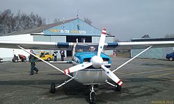
Havlíčkův Brod Airfield
Appearance
Havlíčkův Brod Airport Letiště Havlíčkův Brod | |||||||||||
|---|---|---|---|---|---|---|---|---|---|---|---|
 | |||||||||||
| Summary | |||||||||||
| Airport type | Public, no Pudlic International airport | ||||||||||
| Operator | Aeroport Havlickuv Brod | ||||||||||
| Serves | Havlíčkův Brod | ||||||||||
| Location | 0.5 kilometres (0.31 mi) SW from Havlickuv Brod | ||||||||||
| Elevation AMSL | 1,519 ft / 465 m | ||||||||||
| Coordinates | 49°35′50″N 015°32′57″E / 49.59722°N 15.54917°E | ||||||||||
| Website | www.aeroklubhb.cz | ||||||||||
 | |||||||||||
| Runways | |||||||||||
| |||||||||||
Havlíčkův Brod Airport (Czech: Letiště Havlíčkův Brod) (ICAO: LKHB[1][2]) is a public aerodrome and no public international airport with civil traffic. It is situated approximately 1.8 kilometres (1 mi) southwest of Havlíčkův Brod, a town in the Vysočina Region of the Czech Republic, at the border of Czech highlands. The airport is plentifully used for sport flying and sightseeing flights above the Czech highlands.
References
- ^ Airport information for LKHB at Great Circle Mapper.
- ^ Accident history for LKHB at Aviation Safety Network
