
Hazel Hurst, Pennsylvania
Hazel Hurst, Pennsylvania | |
|---|---|
Unincorporated community | |
 Hazel Hurst | |
| Coordinates: 41°42′21″N 78°34′57″W / 41.70583°N 78.58250°W | |
| Country | United States |
| State | Pennsylvania |
| County | McKean |
| Elevation | 1,729 ft (527 m) |
| Time zone | UTC-5 (Eastern (EST)) |
| • Summer (DST) | UTC-4 (EDT) |
| ZIP code | 16733 |
| Area code | 814 |
| GNIS feature ID | 1176710[1] |
Hazel Hurst is an unincorporated community in McKean County, Pennsylvania, United States.[1] The community is located along U.S. Route 6 3.2 miles (5.1 km) east-southeast of Mount Jewett. Hazel Hurst has a post office with ZIP code 16733.[2][3]
References
- ^ a b "Hazel Hurst". Geographic Names Information System. United States Geological Survey, United States Department of the Interior.
- ^ United States Postal Service. "USPS - Look Up a ZIP Code". Retrieved July 23, 2017.
- ^ "Postmaster Finder - Post Offices by ZIP Code". United States Postal Service. Retrieved July 23, 2017.
Municipalities and communities of McKean County, Pennsylvania, United States | ||
|---|---|---|
| City | 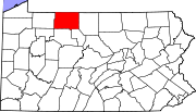 | |
| Boroughs | ||
| Townships | ||
| CDPs | ||
| Unincorporated communities | ||
This McKean County, Pennsylvania state location article is a stub. You can help Wikipedia by expanding it. |