
Helmville, Montana
Helmville, Montana | |
|---|---|
| Country | United States |
| State | Montana |
| County | Powell |
| Elevation | 4,308 ft (1,313 m) |
| Time zone | UTC-7 (Mountain (MST)) |
| • Summer (DST) | UTC-6 (MDT) |
| ZIP code | 59843 |
| Area code | 406 |
| GNIS feature ID | 784755[1] |
Helmville is an unincorporated community in Powell County, Montana, United States. Helmville is located in the central section of the county near Montana Highway 141, 13 miles (21 km) southeast of Ovando. The community has a post office with ZIP code 59843.[2][3]
References
- ^ "Helmville". Geographic Names Information System. United States Geological Survey, United States Department of the Interior.
- ^ United States Postal Service (2012). "USPS - Look Up a ZIP Code". Retrieved 2012-02-15.
- ^ "Postmaster Finder - Post Offices by ZIP Code". United States Postal Service. Retrieved July 9, 2014.
Municipalities and communities of Powell County, Montana, United States | ||
|---|---|---|
| City | 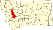 | |
| CDPs | ||
| Other community | ||
This Montana state location article is a stub. You can help Wikipedia by expanding it. |