
Higashi-Rinkan Station
Higashi-Rikan Station 東林間駅 | |||||
|---|---|---|---|---|---|
 The east entrance in December 2016 | |||||
| General information | |||||
| Location | 7-7-1 Kamitsuruma, Minami-ku, Sagamihara-shi, Kanagawa-ken Japan | ||||
| Operated by | |||||
| Line(s) | |||||
| Distance | 33.8 km from Shinjuku | ||||
| Platforms | 2 side platforms | ||||
| Tracks | 2 | ||||
| Connections | Bus stop | ||||
| Other information | |||||
| Website | www | ||||
| History | |||||
| Opened | 1 April 1929 | ||||
| Rebuilt | 1982 | ||||
| Previous names | Higashi-Rikantoshi (until 1941) | ||||
| Passengers | |||||
| FY2015 | 21,460 daily | ||||
| |||||

Higashi-Rinkan Station (東林間駅, Higashi-Rinkan-eki) is a railway station on the Odakyu Enoshima Line in the city of Sagamihara, Kanagawa, Japan, operated by the private railway operator Odakyu Electric Railway.
Lines
Higashi-Rinkan Station is served by the Odakyu Enoshima Line, with some through services to and from Shinjuku in Tokyo. It lies 33.8 kilometers from Shinjuku.
Station layout
Higashi-Rikan Station has two opposed side platforms serving two tracks. The station building is elevated above the platforms and tracks.
Platforms
| 1 | ■ Odakyu Enoshima Line | for Fujisawa and Katase-Enoshima |
| 2 | ■ Odakyu Enoshima Line | for Sagami-Ono and Shinjuku |
-
 The west entrance in December 2016
 -
 The ticket barriers in December 2016
 -
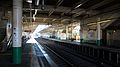
 The south end of the platforms in December 2016
 -
 The north end of the platforms in December 2016


.jpg)
.jpg)
Adjacent stations
| ← | Service | → | ||
|---|---|---|---|---|
| Odakyu Enoshima Line | ||||
| Sagami-Ono | Local | Chūō-Rinkan | ||
History
The station opened on April 1, 1929, as Higashi-Rinkantoshi Station (東林間都市駅). Its name was shortened to Higashi-Rinkan on October 15, 1941. The station building was rebuilt in 1982.[citation needed]
See also
External links
Wikimedia Commons has media related to Higashi-Rinkan Station.