
High West
| High West | |
|---|---|
| Mo Tin Leng (摩天嶺) | |
 High West from Mount Davis | |
| Highest point | |
| Elevation | 494 m (1,621 ft) Hong Kong Principal Datum |
| Naming | |
| Native name | 西高山 Error {{native name checker}}: parameter value is malformed (help) |
| Geography | |
 High West Location of High West in Hong Kong | |
| Location | Hong Kong Island |
High West (Chinese: 西高山) is a mountain in Hong Kong Island, Hong Kong.
The mountain has a height of 494 m (1,621 ft). It is west of Victoria Peak, north of Pok Fu Lam and south of Lung Fu Shan.[1] Queen Mary Hospital is at its west slope and Harlech Road passes its north slope. Hatton Road and Lugard Road end in the pass between High West and Victoria Peak. The mountain is located within Pok Fu Lam Country Park.[2]
Although not as high as Victoria Peak, its peak is a much less touristed location than the previous,which offers panoramic views over the western and southern sides of the island, as well as Kowloon and parts of New Territories to the north. A small trail near the junction of Hatton, Lugard and Harlech Roads leads to the top. On clear days, Tai Mo Shan, Tsuen Wan and East Lamma Channel can be visible.[3]
Gallery
-

-

-
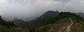 Panorama from the tip of High West
 -
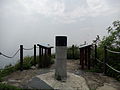 The triangulation station atop High West


See also
22°16′21″N 114°08′11″E / 22.272452°N 114.136292°E
References
This Hong Kong Island location article is a stub. You can help Wikipedia by expanding it. |
This article related to a mountain or hill in Hong Kong is a stub. You can help Wikipedia by expanding it. |