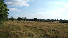
Horton Country Park

Horton Country Park is a wooded recreation area on land to the west of Epsom, Surrey.
Description
Horton Country Park is a wooded recreation/amenities area occupying the east of a narrow upland watershed between two tributaries. As such, the summit being the parish divide, it is in traditional terms, within Epsom parish and occupies land due west of the town, and due east of the semi-rural, semi-urban London district of Chessington.[1] It is a Local Nature Reserve.[2][3][4]
Part of the area is occupied by Hobbledown Children's Farm. The Horton Light Railway used to run through this land from Ewell West railway station to the five psychiatric hospitals owned by the London County Council, known as the Epsom Cluster. Parts of the landscaped grounds of these hospitals have now been incorporated into the country park.
The Thames Down Link long distance footpath from Kingston upon Thames to Box Hill station passes through the park.[5]
References
- ^ Epsom parish The Church of England Retrieved 2014-01-30
- ^ "Horton Country Park". Local Nature Reserves. Natural England.
- ^ "Map of Horton Country Park". Local Nature Reserves. Natural England.
- ^ H.E. Malden (editor) (1911). "Introduction [and map of the parishes of this part of Surrey]". A History of the County of Surrey: Volume 3. Institute of Historical Research. Retrieved 30 January 2014.
{{cite web}}:|author=has generic name (help) - ^ "Thames Down Link" (PDF). Surrey County Council. Retrieved 6 January 2011.

