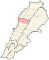
Hsoun
Appearance
Hsoun
الحصون El-Houssoun | |
|---|---|
| Coordinates: 34°5′34″N 35°44′11″E / 34.09278°N 35.73639°E | |
| Country | Lebanon |
| Governorate | Mount Lebanon |
| District | Jbeil |
| Area | |
| • Total | 512 ha (1,265 acres) |
| Elevation | 916 m (3,005 ft) |
Hsoun (Arabic: الحصون, also spelled el-Houssoun) is a municipality in the Jbeil District of Mount Lebanon Governorate, Lebanon. It is 73 kilometers north of Beirut. Bejjeh has an average elevation of 916 meters above sea level and a total land area of 512 hectares. There were four companies with more than five employees operating in the village as of 2008.[1] Its inhabitants are predominantly Maronite Catholics and Shia Muslims.[2]
References
- ^ "Hsoun". Localiban. Localiban. 2008-01-16. Retrieved 2016-02-12.
- ^ "Elections municipales et ikhtiariah au Mont-Liban" (PDF). Localiban. Localiban. 2010. p. 19. Archived from the original (pdf) on 2015-07-24. Retrieved 2016-02-12.
{{cite web}}: Unknown parameter|deadurl=ignored (|url-status=suggested) (help)


