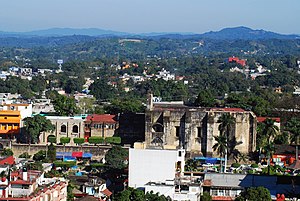
Huejutla de Reyes
Huejutla de Reyes | |
|---|---|
Municipality and town | |
 | |
| Coordinates: 21°08′N 98°25′W / 21.133°N 98.417°W | |
| Country | |
| State | Hidalgo |
| Municipal seat | Huejutla de Reyes |
| Area | |
| • Total | 377.8 km2 (145.9 sq mi) |
| Population (2005) | |
| • Total | 115,786 |
Huejutla de Reyes is a city and one of the 84 municipalities of Hidalgo, in central-eastern Mexico. The name comes from the Nahuatl huexotl ("willow") and tlan ("place"),[1] while "de Reyes" commemorates local cobbler Antonio Reyes Cabrera who died defending Huejutla from French invaders in 1866.[2]
The municipality covers an area of 377.8 km2 in the northeast of Hidalgo, in the Huasteca region, on the border with the state of Veracruz. As of 2005, the municipality had a total population of 115,786.[3] but only 36,305 live in the metropolitan area, whereas the remaining population live in various small communities. Around 73,200 people speak indigenous languages, primarily Huasteca Nahuatl.[4]
It has been called "the Heart of La Huasteca".[5]
Geography
[edit]Climate
[edit]Huejutla de Reyes has a tropical monsoon climate (Köppen Am) featuring short, but extremely hot springs and also short, warm winters with cool mornings. The average high temperature in June is 34.4 °C (93.9 °F), with an average minimum temperature in June of 21.5 °C (70.7 °F). The average high temperature in January is 24.5 °C (76.1 °F), with an average minimum temperature in January of 11.5 °C (52.7 °F). The highest temperature ever recorded in Huejutla de Reyes is 50.0 °C (122 °F), recorded on April 26, 2017.[6] A low temperature of -3.0 °C (26.6 °F) was recorded on December 14, 1997. Annual precipitation is 1,463.7 millimetres (57.626 in); July and September being the wettest months.
| Climate data for Huejutla de Reyes, Hidalgo (1981–2010, extremes (1977–present) | |||||||||||||
|---|---|---|---|---|---|---|---|---|---|---|---|---|---|
| Month | Jan | Feb | Mar | Apr | May | Jun | Jul | Aug | Sep | Oct | Nov | Dec | Year |
| Record high °C (°F) | 38.0 (100.4) |
38.0 (100.4) |
41.0 (105.8) |
50.0 (122.0) |
49.0 (120.2) |
47.0 (116.6) |
42.0 (107.6) |
39.0 (102.2) |
40.0 (104.0) |
38.0 (100.4) |
38.0 (100.4) |
34.0 (93.2) |
50.0 (122.0) |
| Mean daily maximum °C (°F) | 24.5 (76.1) |
26.3 (79.3) |
29.0 (84.2) |
32.0 (89.6) |
34.0 (93.2) |
34.4 (93.9) |
33.1 (91.6) |
33.5 (92.3) |
32.0 (89.6) |
30.3 (86.5) |
27.4 (81.3) |
25.1 (77.2) |
30.1 (86.2) |
| Daily mean °C (°F) | 18.0 (64.4) |
19.3 (66.7) |
21.8 (71.2) |
24.9 (76.8) |
27.1 (80.8) |
27.9 (82.2) |
27.0 (80.6) |
27.1 (80.8) |
26.2 (79.2) |
24.2 (75.6) |
21.2 (70.2) |
18.8 (65.8) |
23.6 (74.5) |
| Mean daily minimum °C (°F) | 11.5 (52.7) |
12.2 (54.0) |
14.6 (58.3) |
17.8 (64.0) |
20.3 (68.5) |
21.5 (70.7) |
20.9 (69.6) |
20.8 (69.4) |
20.3 (68.5) |
18.2 (64.8) |
14.9 (58.8) |
12.4 (54.3) |
17.1 (62.8) |
| Record low °C (°F) | −1.0 (30.2) |
2.0 (35.6) |
2.0 (35.6) |
6.0 (42.8) |
10.5 (50.9) |
12.0 (53.6) |
10.0 (50.0) |
11.5 (52.7) |
8.0 (46.4) |
7.0 (44.6) |
3.0 (37.4) |
−3.0 (26.6) |
−3.0 (26.6) |
| Average precipitation mm (inches) | 48.8 (1.92) |
48.7 (1.92) |
51.3 (2.02) |
65.0 (2.56) |
92.5 (3.64) |
177.3 (6.98) |
225.5 (8.88) |
190.3 (7.49) |
278.6 (10.97) |
167.7 (6.60) |
67.9 (2.67) |
50.1 (1.97) |
1,463.7 (57.63) |
| Average precipitation days (≥ 0.1 mm) | 8.0 | 6.9 | 5.5 | 5.6 | 5.1 | 8.5 | 12.3 | 9.8 | 12.3 | 8.6 | 6.9 | 6.9 | 96.4 |
| Source: Servicio Meteorológico Nacional (Average temperatures, 1981-2010 - Extreme temperatures, 1977–2014)[7] | |||||||||||||
Sister cities
[edit] Brownsville, United States (2009)
References
[edit]- ^ "Municipio de Huejutla".
- ^ "Municipio de Huejutla".
- ^ "Huejutla de Reyes". Enciclopedia de los Municipios de México. Instituto Nacional para el Federalismo y el Desarrollo Municipal. Archived from the original on September 27, 2007. Retrieved December 27, 2008.
- ^ Báez Cubero, Lourdes; Garret Ríos, Gabriela; Pérez González, David; Moreno Alcántara, Beatriz; Fierro Alonso, Ulises Julio; Hernández García, Milton Gabriel (2012). Instituto Nacional de Antropología e Historia (ed.). Los pueblos indígenas de Hidalgo: Atlas etnográfico (PDF) (Primera ed.). México, D.F; México. pp. 32–35. ISBN 978-607-484-357-6. Archived from the original (PDF) on 2019-07-25. Retrieved 2019-05-13.
{{cite book}}: CS1 maint: location missing publisher (link) - ^ "Huejutla, el corazón de la Huasteca hidalguense". Hidalgo Brilla (in Spanish). 4 December 2020. Retrieved 16 May 2023.
- ^ "CONAGUA 50 Grados en Huejutla (Spanish)". Retrieved 28 April 2017.
- ^ "Normales Climatológicas para Huejutla (1981-2010)". Servicio Meteorológico Nacional. Retrieved 27 April 2017.


