
IJzendijke
IJzendijke | |
|---|---|
 IJzendijke - de Markt | |
 Flag  Coat of arms | |
| Coordinates: 51°19′17″N 3°36′59″E / 51.32139°N 3.61639°E | |
| Country | Netherlands |
| Province | Zeeland |
| Municipality | Sluis |
| Population (1 January 2009) | 2,155 |

IJzendijke is a city in the municipality of Sluis, about 10 km east of Oostburg, in the Dutch province of Zeeland. Its population in 2001 was 1,780.
The town received city rights in 1303.
IJzendijke was a separate municipality until 1970. Prior to 2003, the city was in the municipality of Oostburg.[1]
Gallery
-
 Central square
 -
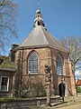 Reformed church
 -
 Church: de Onze Lieve Vrouwe ten Hemelopnemingskerk
 -
 Windmill: de Witte Juffer
 -
 Museum


See also
References
- ^ van der Meer, Ad; Boonstra, Onno (2006). "Repertorium van Nederlandse gemeenten". KNAW. Archived from the original on 2007-02-20.
{{cite web}}: Unknown parameter|deadurl=ignored (|url-status=suggested) (help)
External links
- Template:Kuyper Map of the former municipality in 1868.
Wikimedia Commons has media related to IJzendijke.
51°19′N 3°37′E / 51.317°N 3.617°E
This article about a location in Zeeland is a stub. You can help Wikipedia by expanding it. |