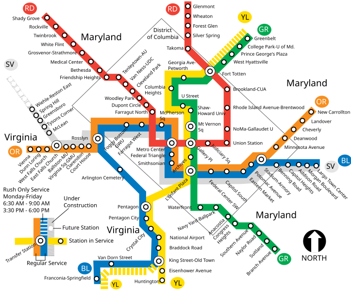
File:WMATA system map.svg
Appearance

Size of this PNG preview of this SVG file: 723 × 599 pixels. Other resolutions: 290 × 240 pixels | 579 × 480 pixels | 927 × 768 pixels | 1,235 × 1,024 pixels | 2,471 × 2,048 pixels | 760 × 630 pixels.
Original file (SVG file, nominally 760 × 630 pixels, file size: 67 KB)
File history
Click on a date/time to view the file as it appeared at that time.
| Date/Time | Thumbnail | Dimensions | User | Comment | |
|---|---|---|---|---|---|
| current | 00:33, 3 December 2013 |  | 760 × 630 (67 KB) | Rfc1394 | Add Silver Line for 2014; drop orange-line rush hour extension; add 5 named stations to silver line; extend silver line to Largo Town Center; add 6 unfinished Silver Line stations; extend District of Columbia line slightly to keep silver line inside DC |
| 20:34, 19 June 2012 |  | 760 × 630 (65 KB) | Rfc1394 | Correct to place Benning Road station inside DC box | |
| 20:32, 19 June 2012 |  | 760 × 630 (65 KB) | Rfc1394 | Correct label "district of columbia" to be text instead of flowroot (technical problem) | |
| 20:31, 19 June 2012 |  | 760 × 630 (65 KB) | Rfc1394 | Add gray square for District of Columbia | |
| 20:16, 19 June 2012 |  | 760 × 630 (63 KB) | Rfc1394 | Make slight adjustment to Yellow Line Rush-Plus switch to Franconia-Springfield station to clarify that the train turns to the new routing starting from King Street station, not from Eisenhower Avenue Station. | |
| 17:59, 4 June 2012 |  | 760 × 630 (63 KB) | Rfc1394 | Adjust "under construction" indicator so it's not butted up next to rush-hour legend | |
| 17:56, 4 June 2012 |  | 760 × 630 (62 KB) | Rfc1394 | Add new Silver Line; add indicators for line name for the color blind; add new additional rush-hour extended service; move legend to bottom left | |
| 23:52, 5 November 2011 |  | 760 × 630 (45 KB) | Train2104 | Official colors, new station names | |
| 22:54, 14 October 2011 |  | 760 × 630 (110 KB) | Rfc1394 | Reverted to version as of 19:52, 10 October 2009 - I messed up | |
| 22:52, 14 October 2011 |  | 760 × 630 (121 KB) | Rfc1394 | Add DC Line |
File usage
The following 3 pages use this file:
Global file usage
The following other wikis use this file:
- Usage on en.wikinews.org
- Usage on es.wikipedia.org
- Usage on es.wikinews.org

