
Independence, Oklahoma
Independence, Oklahoma | |
|---|---|
 Independence Location within the state of Oklahoma | |
| Coordinates: 35°43′31″N 98°56′20″W / 35.72528°N 98.93889°W | |
| Country | United States |
| State | Oklahoma |
| County | Custer |
| Time zone | UTC-6 (Central (CST)) |
| • Summer (DST) | UTC-5 (CDT) |
Independence is a ghost town in Custer County, Oklahoma, United States. It was one of two communities established on the Cheyenne and Arapaho reservations before those reservations were opened to settlement in 1892. Independence had a post office from October 5, 1892, to July 15, 1922. At its peak, the community was served by two newspapers, the Independence Herald and Independence Courier. Ultimately, Independence failed after being bypassed by nearby railroads, and the townsite is now agricultural fields.[1]
References
- ^ Morris, John (1977). Ghost Towns of Oklahoma. Norman, Oklahoma: University of Oklahoma Press. p. 229. ISBN 9780806114200.
{{cite book}}: Cite has empty unknown parameter:|coauthors=(help)
External links
Municipalities and communities of Custer County, Oklahoma, United States | ||
|---|---|---|
| Cities | 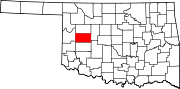 | |
| Towns | ||
| Unincorporated communities | ||
| Ghost town | ||
| Footnotes | ‡This populated place also has portions in an adjacent county or counties | |
This Oklahoma state location article is a stub. You can help Wikipedia by expanding it. |