Irabere River
| Irabere River | |
|---|---|
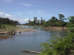
 The river running along the western border of Lautém municipality | |
| Native name |
|
| Location | |
| Country | East Timor |
| Municipalities | |
| Physical characteristics | |
| Mouth | Timor Sea |
• location | Irabin Leteria, Viqueque |
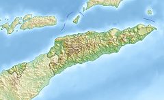
• coordinates | 8°45′29″S 126°43′52″E / 8.7581°S 126.7311°E |
| Basin size | ~ 489 km2 (189 sq mi) |
The Irabere River, sometimes spelt Irebere River (Portuguese: Ribeira de Irabere or Rio Irabere, Tetum: Mota Irabere), is a river in East Timor, a country occupying the eastern end of the island of Timor in the Lesser Sunda Islands of Wallacea.
Course
[edit]The river is one of the country's few perennial rivers.[1] It flows south into the Timor Sea, forming the border between Lautém District to the east and Viqueque District to the west. Its estuary and adjacent forested land forms part of the Irabere estuary and Iliomar forest Important Bird Area.[2]
Catchment
[edit]The catchment or drainage basin of the river is one of East Timor's 10 major catchments,[3] and is approximately 489 km2 (189 sq mi) in area.[4]: 2, 52
East Timor has been broadly divided into twelve 'hydrologic units', groupings of climatologically and physiographically similar and adjacent river catchments.[4]: 2, 52 [5] The Irabere River catchment is one of the four major catchments in the Irabere hydrologic unit, which is about 1,619.6 km2 (625.3 sq mi) in total area; the others are the catchments of the Namaluto, Bebui and Cuha Rivers.[4]: 9, 52, 58
See also
[edit]References
[edit]- ^ Nunes, Mario N. (Manager ETTA Forestry Unit) (26 January 2001). "The Natural Resources of East Timor: A physical, geographical and ecological review". In Anderson, Russell; Deutsch, Carolyn (eds.). Sustainable Development and the Environment in East Timor: Proceedings of the Conference on Sustainable Development in East Timor, held from 25-31 January 2001. Conference on Sustainable Development in East Timor. Dili: Timor Aid. ISBN 0646417169. Archived from the original on 24 July 2021. Retrieved 30 July 2022.
- ^ "Irebere estuary and Iliomar forest". Important Bird Areas factsheet. BirdLife International. 2014. Retrieved 22 March 2014.
- ^ The National Biodiversity Strategy and Action Plan of Timor-Leste (2011 – 2020) (PDF) (Report) (rev. ed.). Democratic Republic of Timor-Leste. 2015. p. 72. Retrieved 16 April 2022.
- ^ a b c Costin, Graham; Powell, Bronwyn (2006). Situation Analysis Report: Timor-Leste (PDF) (Report). Brisbane: International WaterCentre. Retrieved 6 July 2022.
- ^ AQUASTAT Country Profile – Timor-Leste (PDF) (Report). Rome: Food and Agriculture Organization of the United Nations (FAO). 2011. p. 4. Retrieved 25 June 2022.
External links
[edit]![]() Media related to Irebere River at Wikimedia Commons
Media related to Irebere River at Wikimedia Commons

