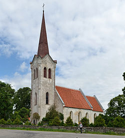
Jõelähtme
Jõelähtme | |
|---|---|
Village | |
 Jõelähtme church | |
| Country | |
| County | Harju County |
| Parish | Jõelähtme Parish |
| Area | |
| • Total | 211 km2 (81 sq mi) |
| Time zone | UTC+2 (EET) |
| • Summer (DST) | UTC+3 (EEST) |
Jõelähtme (German: Jegelecht) is a village in Jõelähtme Parish, Harju County, northern Estonia.
Population
| Year | Counted population with date of 1st of january[1] |
|---|---|
| 2001 | 5236 |
| 2002 | 5210 |
| 2003 | 5203 |
| 2004 | 5205 |
| 2005 | 5199 |
| 2006 | 5197 |
| 2007 | 5221 |
| 2008 | 5235 |
| 2009 | 5258 |
| 2010 | 5279 |
Islands
Allu, Koipsi, Laikari, Lõuna-Malusi, Põhja-Malusi, Rammu, Rohusi, Umbloo, Vahekari
-
Linnamäe hydroelectric power station on Jägala River.
References
- ^ Statistika andmebaas: rahvaarv ja rahvastiku koosseis. Statistikaamet, vaadatud 8. juunil 2011
External links
- Official website (in Estonian)
- Jõelähtme Contact info on eesti.ee Jõelähtme parish contact info in Estonian Citizen portal


