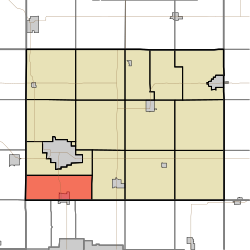
Jackson Township, Bremer County, Iowa
Appearance
Jackson Township, Bremer County | |
|---|---|
 | |
| Coordinates: 42°39′53″N 092°28′18″W / 42.66472°N 92.47167°W | |
| Country | |
| State | |
| County | Bremer |
| Area | |
| • Total | 24.35 sq mi (63.08 km2) |
| • Land | 24.28 sq mi (62.89 km2) |
| • Water | 0.07 sq mi (0.19 km2) |
| Elevation | 919 ft (280 m) |
| Population (2010) | |
| • Total | 1,446 |
| • Density | 59.6/sq mi (22.3/km2) |
| Time zone | UTC-6 (Central) |
| • Summer (DST) | UTC-5 (Central) |
| FIPS code | 19-92097[2] |
| GNIS feature ID | 0468093 |
Jackson Township is one of fourteen townships in Bremer County, Iowa, USA. At the 2010 census, its population was 1,446.[3]
Geography
Jackson Township covers an area of 24.35 square miles (63.1 km2) and contains one incorporated settlement, Janesville. According to the USGS, it contains three cemeteries: Oakland, Pilot Mound and Waverly Junction.
References
- ^ "US Board on Geographic Names". United States Geological Survey. 2007-10-25. Retrieved 2008-01-31.
- ^ "American FactFinder". United States Census Bureau. Archived from the original on September 11, 2013. Retrieved 2008-01-31.
{{cite web}}: Unknown parameter|deadurl=ignored (|url-status=suggested) (help) - ^ "IA - Jackson township". United States Census Bureau. Retrieved March 17, 2013.
External links

