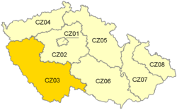
Jihozápad
Appearance
Jihozápad | |
|---|---|
NUTS2 Region | |
 | |
| Country | |
| Area | |
| • Total | 17,617 km2 (6,802 sq mi) |
| Population (01/2016) | |
| • Total | 1,214,450 |
| • Density | 69/km2 (180/sq mi) |
| Time zone | UTC+1 (CET) |
| • Summer (DST) | UTC+2 (CEST) |
| NUTS code | CZ03 |
| GDP per capita (PPS) | € 16,800 (2006)[1] |
Jihozápad (Southwest) is statistical area of the Nomenclature of Territorial Units for Statistics, level NUTS 2. It includes the Plzeň Region and the South Bohemian Region.
It covers an area of 17 617 km² and 1,214,450 inhabitants (population density 67 inhabitants/km²).
