Joppa, Illinois
Joppa | |
|---|---|
 Joppa | |
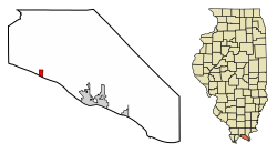
 Location of Joppa in Massac County, Illinois. | |
 Location of Illinois in the United States | |
| Coordinates: 37°12′27″N 88°50′35″W / 37.20750°N 88.84306°W | |
| Country | United States |
| State | Illinois |
| County | Massac |
| Area | |
| • Total | 0.50 sq mi (1.30 km2) |
| • Land | 0.49 sq mi (1.26 km2) |
| • Water | 0.02 sq mi (0.05 km2) |
| Population (2010) | |
| • Total | 360 |
| • Estimate (2016)[2] | 341 |
| • Density | 701.65/sq mi (271.02/km2) |
| Time zone | UTC-6 (CST) |
| • Summer (DST) | UTC-5 (CDT) |
| ZIP Code(s) | 62953 |
| Area code | 618 |
| FIPS code | 17-38674 |
| Wikimedia Commons | Joppa, Illinois |
Joppa is a village in Massac County, Illinois, United States, along the Ohio River. The population was 409 in year 2000. It is part of the Paducah, KY-IL Micropolitan Statistical Area.
History
During the first of the 19th century, a riverboat landing known as Copeland's Landing operated at what is now Joppa. In the early 1870s, A.J. Kuykendall, a prominent local land owner, and Jesse Baccus, who operated a local sawmill, decided to establish a town. They named the town after the Biblical city of Joppa (in modern Israel). After the arrival of the railroad in 1900, the village thrived for several years as a river-to-rail transloading station. Joppa incorporated in 1901.[3]
Geography
Joppa is located at 37°12′27″N 88°50′35″W / 37.20750°N 88.84306°W (37.207399, -88.843033).[4] The village lies along the Ohio River downstream from Metropolis, Illinois, and Paducah, Kentucky. County Road 5 connects Joppa with U.S. Route 45 near Metropolis to the east. The Joppa Generating Station, a coal and natural gas power plant operated by Electric Energy, Inc., lies just west of the village.
According to the 2010 census, Joppa has a total area of 0.508 square miles (1.32 km2), of which 0.49 square miles (1.27 km2) (or 96.46%) is land and 0.018 square miles (0.05 km2) (or 3.54%) is water.[5]
Demographics
| Census | Pop. | Note | %± |
|---|---|---|---|
| 1910 | 734 | — | |
| 1920 | 651 | −11.3% | |
| 1930 | 462 | −29.0% | |
| 1940 | 587 | 27.1% | |
| 1950 | 513 | −12.6% | |
| 1960 | 578 | 12.7% | |
| 1970 | 531 | −8.1% | |
| 1980 | 535 | 0.8% | |
| 1990 | 492 | −8.0% | |
| 2000 | 409 | −16.9% | |
| 2010 | 360 | −12.0% | |
| 2016 (est.) | 341 | [2] | −5.3% |
| U.S. Decennial Census[6] | |||
2010
Whereas according to the 2010 U.S. Census Bureau: 360 persons
- 89.2% White; 85.8% White, non-Hispanic
- 8.6% Black
- 0.6% Native American
- 0.0% Asian
- 0.0% Native Hawaiian or Pacific Islander
- 1.7% Two or more races
- 0.0% Other races
- 3.3% Hispanic or Latino (all White)
2000
In 2000, there were 409 people, 165 households, and 110 families residing in the village.[7] The population density was 838.2 people per square mile (322.3/km²). There were 203 housing units at an average density of 416.0 per square mile (160.0/km²). The racial makeup of the village was 88.26% White, 7.58% African American, 0.24% Native American, 0.98% from other races, and 2.93% from two or more races. Hispanic or Latino of any race were 2.44% of the population.
There were 165 households out of which 32.1% had children under the age of 18 living with them, 48.5% were married couples living together, 12.7% had a female householder with no husband present, and 33.3% were non-families. 28.5% of all households were made up of individuals and 8.5% had someone living alone who was 65 years of age or older. The average household size was 2.48 and the average family size was 3.09.
In the village, the population was spread out with 27.6% under the age of 18, 8.3% from 18 to 24, 24.4% from 25 to 44, 26.9% from 45 to 64, and 12.7% who were 65 years of age or older. The median age was 36 years. For every 100 females there were 109.7 males. For every 100 females age 18 and over, there were 96.0 males.
The median income for a household in the village was $17,813, and the median income for a family was $20,729. Males had a median income of $23,750 versus $16,607 for females. The per capita income for the village was $8,890. About 34.3% of families and 44.6% of the population were below the poverty line, including 65.1% of those under age 18 and 20.0% of those age 65 or over.
See also
References
- ^ "2016 U.S. Gazetteer Files". United States Census Bureau. Retrieved Jun 29, 2017.
- ^ a b "Population and Housing Unit Estimates". Retrieved June 9, 2017.
- ^ George W. May, History of Massac County, Illinois (Wagoner Printing Company, 1955), pp. 192-194. Accessed at archive.org.
- ^ "US Gazetteer files: 2010, 2000, and 1990". United States Census Bureau. 2011-02-12. Retrieved 2011-04-23.
- ^ "G001 - Geographic Identifiers - 2010 Census Summary File 1". United States Census Bureau. Retrieved 2015-08-04.
- ^ "Census of Population and Housing". Census.gov. Archived from the original on May 12, 2015. Retrieved June 4, 2015.
{{cite web}}: Unknown parameter|deadurl=ignored (|url-status=suggested) (help) - ^ "American FactFinder". United States Census Bureau. Retrieved 2008-01-31.
External links
 Media related to Joppa, Illinois at Wikimedia Commons

