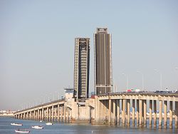
José León de Carranza Bridge
Appearance
You can help expand this article with text translated from the corresponding article in Spanish. (May 2010) Click [show] for important translation instructions.
|
Jose Leon de Carranza Bridge | |
|---|---|
 | |
| Coordinates | 36°29′59″N 6°15′17″W / 36.49972°N 6.25472°W |
| Carries | N-443 |
| Crosses | Bay of Cádiz |
| Locale | |
| Characteristics | |
| Design | Bascule bridge |
| Total length | 1.400 m |
| Width | 13 m |
| Height | 18 m (over the sea) |
| Longest span | 90 m |
| History | |
| Opened | October 28, 1969 |
| Statistics | |
| Daily traffic | 40,000 |
| Location | |
 | |
José Leon de Carranza Bridge (also referred to as the Carranza Bridge) is a 1400 m bridge that connects the city of Cadiz to the mainland.[1] The bridge goes over the Bay of Cádiz. It forms part of the national net of roads with the number N-443. It is the first of the two entrances to the city of Cadiz, the second being La Pepa bridge. This bridge is also one of the longest bascule bridges in Europe.
References
- ^ "José León de Carranza Bridge". Structurae.net. Retrieved 29 April 2010.
