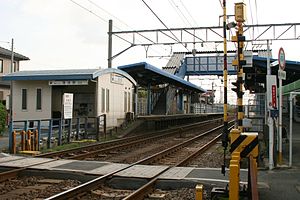
Kabaike Station
Appearance
Kabaike Station 蒲池駅 | |
|---|---|
 Kabaike Station | |
| General information | |
| Location | Kabaike-cho 5-chome 105-banchi, Tokoname, Aichi (愛知県常滑市蒲池町) Japan |
| Operated by | Nagoya Railroad |
| Line(s) | Meitetsu Tokoname Line |
| History | |
| Opened | 1913 |
| Passengers | |
| 2008 | 1,076 daily |
Kabaike Station (蒲池駅, Kabaike-eki) is a railway station operated by Meitetsu's Tokoname Line located in Tokoname, Aichi Prefecture, Japan. It is located 26.4 rail kilometers from the terminus of the line at Jingū-mae Station. [1]
History
Kabaike Station was opened on June 19, 1913 as a station on the Aichi Electric Railway Company. The Aichi Electric Railway became part of the Meitetsu group on August 1, 1935. The station has been unattended since February 1968. In January 2005, the Tranpass system of magnetic fare cards with automatic turnstiles was implemented. [2]
Line
Layout
Kabaike Station has two opposed side platforms connected by an overpass.
Platforms
| 1 | ■ Tokoname Line | For Tokoname and Central Japan International Airport |
| 2 | ■ Tokoname Line | For Ōtagawa and Jingū-mae |
Adjacent stations
| ← | Service | → | ||
|---|---|---|---|---|
| Meitetsu Tokoname Line | ||||
| μSKY Limited Express: Does not stop at this station | ||||
| Limited Express: Does not stop at this station | ||||
| Rapid Express: Does not stop at this station | ||||
| Nishinokuchi | Express (1 train for Central Japan Int'l Airport) | Enokido | ||
| Semi Express: Does not stop at this station | ||||
| Nishinokuchi | Local | Enokido | ||
References
- ^ 蒲池 [KABAIKE] (in Japanese). Nagoya Railroad. Retrieved 25 February 2015.
- ^ 鷲田, 鉄也 (September 2010), クロニクル常滑線, 週刊朝日百科, 週刊歴史でめぐる鉄道全路線 (in Japanese), no. 9, Japan: Asahi Shimbun Publications, Inc., p. 9, ISBN 978-4-02-340139-6
External links
- Official web page Template:Ja icon
 Media related to Kabaike Station at Wikimedia Commons
34°54′56″N 136°49′34″E / 34.9155°N 136.826°E
