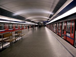
Kabaty metro station
Appearance
Kabaty | |||||||||||
|---|---|---|---|---|---|---|---|---|---|---|---|
 | |||||||||||
| General information | |||||||||||
| Coordinates | 52°7′55″N 21°3′54″E / 52.13194°N 21.06500°E | ||||||||||
| Owned by | ZTM | ||||||||||
| Platforms | 1 island platform | ||||||||||
| Tracks | 2 | ||||||||||
| Connections | |||||||||||
| Construction | |||||||||||
| Platform levels | 1 | ||||||||||
| Other information | |||||||||||
| Station code | A-1 | ||||||||||
| Fare zone | 1 | ||||||||||
| History | |||||||||||
| Opened | 7 April 1995 | ||||||||||
| Services | |||||||||||
| |||||||||||
Metro Kabaty is the southern terminus of Line M1 of the Warsaw Metro, located in the Kabaty neighbourhood of the Ursynów district in the south of Warsaw, at the end of Aleja Komisji Edukacji Narodowej, the main artery of Ursynów. Tracks continue beyond the station, where they rise to surface level and go into the depot. The station is close to a Tesco supermarket and several bus stops. The Kabaty Forest is nearby.[1]
References
- ^ "Kabaty Forest, Warsaw". VirtualTourist.com. Retrieved 23 April 2015.
This article needs additional citations for verification. (September 2014) |
External links
![]() Media related to Kabaty metro station at Wikimedia Commons
Media related to Kabaty metro station at Wikimedia Commons

