Kabgani
Kabgani | |
|---|---|
 Kabgani in 2009 | |
 | |
| Country | |
| Province | Khyber Pakhtunkhwa |
| District | Swabi |
| Time zone | UTC+5 (PST) |
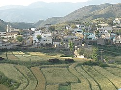
Kabgani is an administrative unit, known as Union council of Swabi District in the Khyber Pakhtunkhwa province of Pakistan. Further more Kabgani is a village located in the Swabi district of Khyber Pakhtunkhwa (KPK), Pakistan. It's a rural area with a rich cultural heritage and history. The village is surrounded by lush green fields, orchards, and mountains, making it a beautiful and peaceful place.
District Swabi has 4 Tehsils i.e. Swabi Tehsil, Lahor, Topi Tehsil and Razar. Each Tehsil comprises certain numbers of union councils. There are 56 union councils in district Swabi. Word Kabgani meaning Kabgani is a term that may have different meanings depending on the context. Here are a few possible interpretations:
1. Kabgani is a Hindi word that means "hidden" or "secret". 2. In Urdu, Kabgani means "mystery" or "enigma". 3. In some African cultures, Kabgani is a name that means "gift" or "blessing".
See also
[edit]External links
[edit]- Khyber-Pakhtunkhwa Government website section on Lower Dir
- United Nations
- HAJJ website Uploads[permanent dead link]
- PBS paiman.jsi.com Archived 2015-01-22 at the Wayback Machine
34°11′N 72°41′E / 34.183°N 72.683°E
