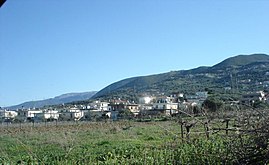
Kallithea, Achaea
Kallithea
Καλλιθέα | |
|---|---|
Settlement | |
 | |
| Coordinates: 38°9.8′N 21°43.8′E / 38.1633°N 21.7300°E | |
| Country | Greece |
| Geographic region | Peloponnese |
| Administrative region | West Greece |
| Regional unit | Achaea |
| Municipality | Patras |
| Municipal unit | Messatida |
| Districts | 2 |
| Elevation | 220 m (720 ft) |
| Population (2011)[1] | |
| • Rural | 691 |
| • Community | 837 |
| Time zone | UTC+2 (EET) |
| • Summer (DST) | UTC+3 (EEST) |
| Postal code | 265 00 |
| Vehicle registration | AX |
Kallithea (Greek: Καλλιθέα, before 1981: Καλλιθεόκαμπος - Kallitheokampos[2]) is a community in the suburbs of Patras in Achaea, Greece. It is located 9 km south of downtown Patras, on the Greek National Road 33 to Tripoli. The community consists of the villages Kallithea and Ano Kallithea, and is part of the municipal unit Messatida within the municipality of Patras. The nearest villages are Ovrya to the north and Thea to the west. To the east lies the mountain Omplos.
Population
| Year | Population |
|---|---|
| 1981 | 462 |
| 1991 | 509 |
| 2001 | 601 |
| 2011 | 691 |
See also
References
- ^ "Απογραφή Πληθυσμού - Κατοικιών 2011. ΜΟΝΙΜΟΣ Πληθυσμός" (in Greek). Hellenic Statistical Authority.
- ^ Name changes of settlements in Greece

