Kalutara fort
| Kalutara fort | |
|---|---|
| Kalutara, Sri Lanka | |
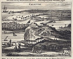
 1672 Dutch engraving of Fort Caletvre | |
| Coordinates | 6°35′13″N 79°57′37″E / 6.587070°N 79.960175°E |
| Type | Defence fort |
| Site information | |
| Condition | Destroyed |
| Site history | |
| Built | 1622 |
| Built by | Portuguese and Dutch |
Kalutara fort (Template:Lang-si Kaluthara Balakotuwa; Template:Lang-ta) was built by the Portuguese in 1622.[1] It was located in Kalutara, Sri Lanka.
In 1574, Portuguese forces, commanded by Diogo de Melo de Castro, devastated the area south of Colombo destroying numerous shrines and temple. In late 1594 Portuguese forces, led by Jerónimo de Azevedo, captured the town of Kalutara. In 1622 the Portuguese and built a fort on the site of the destroyed Gangathilaka temple.[2][3] The fort was constructed under the supervision of Jorge de Albuquerque.[4] It was subsequently captured by King Rajasinghe I of the Sitawaka kingdom. Then still later it was captured by the Dutch and re-captured by the Portuguese.
On 15 October 1655 following a siege by Dutch forces, led by Gerard Hulft, the Portuguese commander of the fort, Anthonio Mendes de Aranha, surrendered the fort and garrison of 255 men, without a shot being fired.[5][6] In 1677 the Dutch fortified it by constructing two additional bastions, increasing the size of the ramparts, digging a moat and erecting a drawbridge.[5] It is reported that the Dutch Governor brought over architects from Netherlands especially to rebuild this fort. Most of the building material was sourced locally however it is reported that certain types of rocks were brought from the Netherlands.[7] In February 1769, it was surrendered to the British, and was used for garrison and residence of the Government Agent.[3][7]
There is no remains of the fort due the construction of Kalutara Vihara on the site.[3][7]
References
- ^ "Kalutara : Diyambetalawa – Caletvre – Calleture". VOC Sri Lanka. Retrieved 17 November 2014.
- ^ "Kalutara District". Ceylon Today. 11 November 2012. Retrieved 17 November 2014.
- ^ a b c "Diyambetalawa: Early Prints from Rijksmuseum, Amsterdam". Defonseka.com. Retrieved 17 November 2016.
- ^ Codrington, H. W. (1929). Short History of Ceylon. Asian Educational Services. p. 112. ISBN 81-206-0946-8.
- ^ a b "Colonial Kalutara". Sunday Times. 2 August 2010. Retrieved 17 November 2014.
- ^ Anthonisz, Richard Gerard (1929). The Dutch in Ceylon: An Account of Their Early Visits to the Island, Their Conquests, and Their Rule Over the Maritime Regions During a Century and a Half. Asian Educational Services. p. 147. ISBN 81-206-1845-9.
- ^ a b c "Kalutara Fort". AmazingLanka.com. Retrieved 17 November 2014.


