Kamphaeng Phet
Appearance
Kamphaeng Phet
กำแพงเพชร | |
|---|---|
Town | |
 Ruins inside the Kamphaeng Phet Historical Park | |
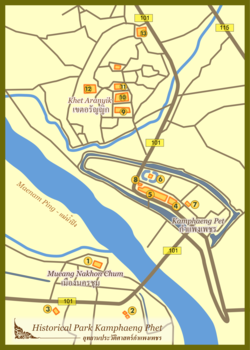
 Map of Kamphaeng Phet | |
| Country | |
| Province | Kamphaeng Phet Province |
| Population (2005) | |
• Total | 30,114 |
| Time zone | UTC+7 (ICT) |
Kamphaeng Phet is a town (thesaban mueang) in northern Thailand, capital of the Kamphaeng Phet Province. It covers the complete tambon Nai Mueang of the Mueang Kamphaeng Phet district. As of 2005 it has a population of 30,114.
Climate
| Climate data for Kamphaeng Phet (1981–2010) | |||||||||||||
|---|---|---|---|---|---|---|---|---|---|---|---|---|---|
| Month | Jan | Feb | Mar | Apr | May | Jun | Jul | Aug | Sep | Oct | Nov | Dec | Year |
| Mean daily maximum °C (°F) | 32.1 (89.8) |
34.4 (93.9) |
36.0 (96.8) |
37.3 (99.1) |
35.2 (95.4) |
33.6 (92.5) |
33.0 (91.4) |
32.6 (90.7) |
32.7 (90.9) |
32.2 (90.0) |
31.6 (88.9) |
30.8 (87.4) |
33.5 (92.2) |
| Mean daily minimum °C (°F) | 18.5 (65.3) |
20.3 (68.5) |
22.7 (72.9) |
24.9 (76.8) |
25.2 (77.4) |
25.1 (77.2) |
24.8 (76.6) |
24.7 (76.5) |
24.4 (75.9) |
23.8 (74.8) |
21.5 (70.7) |
18.5 (65.3) |
22.9 (73.2) |
| Average rainfall mm (inches) | 2.3 (0.09) |
13.1 (0.52) |
36.7 (1.44) |
52.8 (2.08) |
195.5 (7.70) |
165.1 (6.50) |
159.4 (6.28) |
170.5 (6.71) |
268.8 (10.58) |
191.7 (7.55) |
42.0 (1.65) |
6.7 (0.26) |
1,304.6 (51.36) |
| Average rainy days (≥ 1 mm) | 1 | 2 | 4 | 6 | 14 | 19 | 17 | 19 | 18 | 16 | 6 | 1 | 123 |
| Average relative humidity (%) | 71 | 66 | 66 | 66 | 77 | 82 | 82 | 84 | 85 | 84 | 79 | 74 | 76 |
| Source: Thai Meteorological Department (Normal 1981-2010), (Avg. rainy days 1961-1990) | |||||||||||||
See also
External links
 Kamphaeng Phet travel guide from Wikivoyage
- http://www.kppcity.com Website of town (Thai only)
