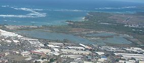
Kanaha Pond State Wildlife Sanctuary
Appearance
| Kanaha Pond State Wildlife Sanctuary | |
|---|---|
IUCN category V (protected landscape/seascape) | |
 Air view of Kanaha Pond | |
Map of Hawaii | |
| Location | Maui, Hawaiʻi |
| Coordinates | 20°53′42″N 156°27′32″W / 20.89500°N 156.45889°W |
| Area | 143 acres (58 ha) |
| Established | 1951 |
| Designated | June 1971 |
Kanaha Pond State Wildlife Sanctuary is a 143-acre (58 ha) wetland in Maui, Hawaii. It is a famous waterfowl sanctuary, home to three endangered Hawaiian bird species, the Hawaiian coot (ʻalae, ʻalae keʻokeʻo) (Fulica alai), the Hawaiian duck (koloa) (Anas wyvilliana), and the Hawaiian (or black-winged) stilt (aeʻo) (Himantopus mexicanus knudseni). Kanaha Pond was designated a state sanctuary in 1951 and a National Natural Landmark in 1971.[1] [2][3]
Gallery
-
Portulaca molokiniensis growing at Kanaha Pond
References
- ^ "National Natural Landmark". National Park Service. Retrieved 12 December 2012.
- ^ James, Van (2001). Ancient Sites of Maui, Molokai'i and Lana'i. Honolulu, HI: Mutual Publishing. pp. 69–70. ISBN 1-56647-529-5.
- ^ "Kahana Pond State Wildlife Sanctuary Maui". HawaiiWeb.com.
External links
Categories:
- IUCN Category V
- Bird sanctuaries of the United States
- Protected areas of Maui
- Wetlands of Hawaii
- Wildlife sanctuaries of the United States
- Landforms of Maui
- Nature reserves in Hawaii
- National Natural Landmarks in Hawaii
- Protected areas established in 1951
- 1951 establishments in Hawaii
- Hawaii geography stubs
- Western United States protected area stubs


