Karigador
Karigador
Carigador d'Istria | |
|---|---|
Village | |
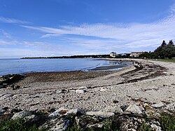
 Beach in Karigador | |
| Coordinates: 45°21′54″N 13°33′33″E / 45.36500°N 13.55917°E | |
| Country | |
| County | |
| Municipality | Brtonigla |
| Government | |
| • predsjednik mjesnog odbora | Olga Sabadin |
| Area | |
| • Total | 1.2 sq mi (3.0 km2) |
| Population (2021)[2] | |
| • Total | 165 |
| • Density | 140/sq mi (55/km2) |
| Time zone | UTC+1 (CET) |
| • Summer (DST) | UTC+2 (CEST) |
| Postal code | 52474 Brtonigla |
| Area code | 052 |
Karigador (Italian: Carigador d'Istria) is a village in the Brtonigla municipality[3] in Istria County, Croatia.
Geography[edit]
Karigador is situated on the western coast of Istria peninsula, six kilometers north of Novigrad and eight kilometers of Umag. Area of municipality extends from Autocamp Umag in the north to Dajla in south.
Demographics[edit]
According to the 2021 census, its population was 165.[2] It was 189 in 2011.[4]
References[edit]
- ^ Register of spatial units of the State Geodetic Administration of the Republic of Croatia. Wikidata Q119585703.
- ^ a b "Population by Age and Sex, by Settlements, 2021 Census". Census of Population, Households and Dwellings in 2021. Zagreb: Croatian Bureau of Statistics. 2022.
- ^ Opći podaci - Brtonigla-Verteneglio (in Croatian)
- ^ "Population by Age and Sex, by Settlements, 2011 Census: Karigador". Census of Population, Households and Dwellings 2011. Zagreb: Croatian Bureau of Statistics. December 2012.

