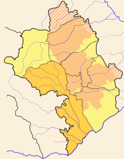
Kashatagh Province
Kashatagh
Քաշաթաղ | |
|---|---|
 | |
| Capital | Berdzor |
| Government | |
| • Governor | Suren Khachatryan |
| Area | |
| • Total | 3,377 km2 (1,304 sq mi) |
| • Rank | Ranked 1st |
| Population (2013)[1] | |
| • Total | 9,656 |
| • Rank | Ranked 6th |
| • Density | 2.9/km2 (7.4/sq mi) |
| Website | official website |

Stepankert not shown.
Kashatagh Region (Armenian: Քաշաթաղի շրջան Kashat'aghi shrjan) is one of the seven regions of the Nagorno-Karabakh Republic which is de facto independent de jure part of Azerbaijan Republic[1] and the largest by area (3,376.60 km2). The population as of 2013 was 9,656. Its capital is Berdzor.
Territorial entities
Kashatagh Region has 54 communities of which 3 are considered urban and 51 are rural.
Geography
Kashtagh borders Shahumyan Region in the north, Martakert Region in the north-east, Askeran Region, Shushi Region and Hadrut Region in the east. Iran in the south and Armenia to the west.
History
The territory on which Kashatag Region was subsequently formed was part of the Syunik Province of the Kingdom of Armenia. In the Middle Ages, there existed Armenian principality. In the valley of the river Akera was the most famous principality Kashatag.[2] The territory remained predominantly Armenian-up to Russian-Persian wars and the South Caucasus invasion of the Ottoman army in the 18th century. Russian forces managed to invade the Caspian provinces of Persia, and in 1723 while simultaneously fighting the Afghans in the east and Turks in the west, Persia was forced to cede the Caspian provinces to the Russian empire. Artsakh Armenian principalities, including Kashatag principality, supported Russia in the war.
Kovsakan is the second largest city in Kashatagh Region after the city of Berdzor.[3] Mher Arakelyan from the ARF Dashnaktsutyun, Razmik Mirzoyan, non-partisan, and Hrach Manucharyan were competing in the mayoral election to be held in June 2008.[4]
Demographics
Kashatagh Region has the highest birth rate in the entire Caucasus region. The birth rate was measured at 29.3 per 1,000 in 2010. On the other hand, the Russian republic of Chechenya, which had a birth rate of 28.9 per 1,000 in 2011 could manage only the second spot.[5]
- Birth Rate: 29.3 per 1,000
- Death Rate: 3.4 per 1,000
- Natural Growth: 2.60% per year
Resettlement of Syrian refugees
By June 2015, an estimated 17,000 of Syria's once 80,000-strong Armenian population had fled the civil war and sought refuge in Armenia.[6] David Babayan, spokesperson of the Karabakh Armenian leader Bako Sahakyan, confirmed that some of those refugees had been resettled in Nagorno-Karabakh.[7] In December 2014, Armenian media cited local municipal authorities in stating that "dozens of Syrian Armenian families" had been resettled in Nagorno Karabakhs Kashtagh region, specifically the city of Berdzor and the village of Ishkhanadzor, also known as Khanlyk.[8]
References
- ^ a b 2005 NKR Census
- ^ V in 1609 the Shah of Persia Abbas I defended its charter the right of the ruler of the principality melik Haykaza. The Persian documents, decrees, kept in Matenadaran (1601-1650's.), V. II, Er., 1957, pp.89-90.
- ^ Kashatagh: Retaking and rebuilding a "third" Armenia in old Lachin - Armenian Diaspora News Forum
- ^ Karabakh News
- ^ http://www.stat-nkr.am/files/yearbooks/2004_2010/5_bnakchut.pdf
- ^ United Nations High Commissioner for Refugees.
- ^ Nana Martirosyan. Давид Бабаян: Армения и Арцах приняли сирийских беженцев, исходя из гуманитарных принципов. ArmInfo. 3 June 2015.
- ^ ПОСЕЛИВШИЕСЯ В АРЦАХЕ СИРИЙСКИЕ АРМЯНЕ ГОВОРЯТ О СВОИХ ЧАЯНИЯХ. NKR News. 26 December 2014.

