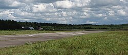
Kauhajoki Airfield
Kauhajoki Airfield Kauhajoen lentokenttä | |||||||||||
|---|---|---|---|---|---|---|---|---|---|---|---|
 | |||||||||||
| Summary | |||||||||||
| Airport type | Privately owned | ||||||||||
| Operator | Kauhajoen Lentokenttä Oy (Kauhajoki Airport Ltd) | ||||||||||
| Location | Kauhajoki, Finland | ||||||||||
| Elevation AMSL | 407 ft / 124 m | ||||||||||
| Coordinates | 62°27′49″N 022°23′28″E / 62.46361°N 22.39111°E | ||||||||||
| Map | |||||||||||
| Runways | |||||||||||
| |||||||||||
Source: VFR Finland[1] | |||||||||||
Kauhajoki Airfield (IATA: KHJ[2], ICAO: EFKJ) is an aerodrome located in Kauhajoki, Finland, about 8 nautical miles (15 km; 9 mi) east-northeast of Kauhajoki centre.[1]
Facilities
The airport resides at an elevation of 407 feet (124 m) above mean sea level. It has one runway designated 07/25 with an asphalt surface measuring 1,160 by 23 metres (3,806 ft × 75 ft).[1]
See also
References
- ^ a b c "Kauhajoki, Finland – EFKJ". VFR Suomi / Finland. Vantaa: Finavia. 18 November 2010. Archived from the original on 21 April 2012. Retrieved 26 August 2011.
{{cite web}}: Unknown parameter|deadurl=ignored (|url-status=suggested) (help) - ^ Accident history for KHJ/EFKJ at Aviation Safety Network

