Kennington Railway Bridge
Appearance
Kennington Railway Bridge | |
|---|---|
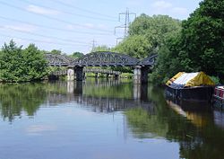
 Kennington Railway Bridge from downstream. Beyond the bridge can be seen the crossing at the confluence of Hinksey Stream. | |
| Coordinates | 51°43′17″N 1°14′32″W / 51.721345°N 1.242253°W |
| Carries | Former Wycombe Railway |
| Crosses | River Thames |
| Locale | Kennington, Oxfordshire |
| Maintained by | Network Rail |
| Characteristics | |
| Height | 13 feet 6 inches (4.11 m)[1] |
| History | |
| Opened | 1923 |
| Location | |
 | |
Kennington Railway Bridge near the village of Kennington, Oxfordshire crosses the River Thames between Sandford Lock and Iffley Lock. It carries the freight railway branch line that serves the BMW Mini factory at Cowley. The freight railway is part of the former Wycombe Railway that linked Maidenhead and Oxford via High Wycombe and Princes Risborough. The current steel bridge was built for the Great Western Railway in 1923. It replaced a wooden bridge built for the Wycombe Railway in 1864. At its western end is the site of the former Iffley Halt railway station.[2]
See also
Railways around Oxford | ||||||||||||||||||||||||||||||||||||||||||||||||||||||||||||||||||||||||||||||||||||||||||||||||||||||||||||||||||||||||||||||||||||||||||||||||||||||||||||||||||||||||||||||||||||||||||||||||||||||||||||||||||
|---|---|---|---|---|---|---|---|---|---|---|---|---|---|---|---|---|---|---|---|---|---|---|---|---|---|---|---|---|---|---|---|---|---|---|---|---|---|---|---|---|---|---|---|---|---|---|---|---|---|---|---|---|---|---|---|---|---|---|---|---|---|---|---|---|---|---|---|---|---|---|---|---|---|---|---|---|---|---|---|---|---|---|---|---|---|---|---|---|---|---|---|---|---|---|---|---|---|---|---|---|---|---|---|---|---|---|---|---|---|---|---|---|---|---|---|---|---|---|---|---|---|---|---|---|---|---|---|---|---|---|---|---|---|---|---|---|---|---|---|---|---|---|---|---|---|---|---|---|---|---|---|---|---|---|---|---|---|---|---|---|---|---|---|---|---|---|---|---|---|---|---|---|---|---|---|---|---|---|---|---|---|---|---|---|---|---|---|---|---|---|---|---|---|---|---|---|---|---|---|---|---|---|---|---|---|---|---|---|---|---|
| ||||||||||||||||||||||||||||||||||||||||||||||||||||||||||||||||||||||||||||||||||||||||||||||||||||||||||||||||||||||||||||||||||||||||||||||||||||||||||||||||||||||||||||||||||||||||||||||||||||||||||||||||||
References
- ^ River Thames Alliance. Bridge heights on the River Thames
- ^ Mitchell, Vic; Smith, Keith (April 2003). "Kennington Junction". Branch Lines to Princes Risborough. Midhurst: Middleton Press. ISBN 1-904474-05-5.
