
Kinsey, Montana
Kinsey, Montana | |
|---|---|
 Kinsey, Montana  Kinsey, Montana | |
| Coordinates: 46°34′15″N 105°39′25″W / 46.57083°N 105.65694°W | |
| Country | United States |
| State | Montana |
| County | Custer |
| Elevation | 2,313 ft (705 m) |
| Time zone | UTC-7 (Mountain (MST)) |
| • Summer (DST) | UTC-6 (MDT) |
| ZIP code | 59338 |
| Area code | 406 |
| GNIS feature ID | 773063[1] |
Kinsey is an unincorporated community in Custer County, Montana, United States. Kinsey is located on Secondary Highway 489 near the Yellowstone River, 14.2 miles (22.9 km) northeast of Miles City. The community has a post office with ZIP code 59338.[2][3]
References
- ^ "Kinsey". Geographic Names Information System. United States Geological Survey, United States Department of the Interior.
- ^ United States Postal Service (2012). "USPS - Look Up a ZIP Code". Retrieved 2012-02-15.
- ^ "Postmaster Finder - Post Offices by ZIP Code". United States Postal Service. Retrieved July 8, 2014.
Municipalities and communities of Custer County, Montana, United States | ||
|---|---|---|
| City | 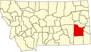 | |
| Town | ||
| Unincorporated communities | ||
This Montana state location article is a stub. You can help Wikipedia by expanding it. |