
Kirby, Montana
Kirby | |
|---|---|
| Country | United States |
| State | Montana |
| County | Bighorn |
| Elevation | 3,880 ft (1,180 m) |
| Population | |
| • Total | N/A |
| Time zone | UTC-7 (Mountain (MST)) |
| • Summer (DST) | UTC-6 (MDT) |
| ZIP code | 59042 |
| Area code | 406 |
| GNIS feature ID | 777090[1] |
Kirby, Montana is a unincorporated community located in Big Horn County at latitude 45.332 and longitude -106.982.
The elevation is 3,878 feet.
History
The town site of Kirby was located on Montana Highway 314, and Cache Creek Road. It was situated directly east of the Crow Indian Reservation and south of the Northern Cheyenne Indian Reservation in the Rosebud Creek valley. A post office was operational 1895 until 1970 with the area code of 59042.
Today, Kirby is a ghost town with no more than a couple remaining buildings, including the former post office.
References
Municipalities and communities of Big Horn County, Montana, United States | ||
|---|---|---|
| City | 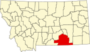 | |
| Town | ||
| CDPs | ||
| Other communities | ||
| Indian reservations | ||
| Footnotes | ‡This populated place also has portions in an adjacent county or counties | |
This Montana state location article is a stub. You can help Wikipedia by expanding it. |