
Kiro, Kansas
Kiro, Kansas | |
|---|---|
 | |
 Kiro  Kiro | |
| Coordinates: 39°05′49″N 95°47′52″W / 39.09694°N 95.79778°W[1] | |
| Country | United States |
| State | Kansas |
| County | Shawnee |
| Elevation | 902 ft (275 m) |
| Time zone | UTC-6 (CST) |
| • Summer (DST) | UTC-5 (CDT) |
| Area code | 785 |
| FIPS code | 20-37250 [1] |
| GNIS ID | 478659 [1] |
Kiro is an unincorporated community in Shawnee County, Kansas, United States.[1]
Demographics
For statistical purposes, the United States Census Bureau has defined Kiro as a census-designated place (CDP).
Education
The community is served by Silver Lake USD 372 public school district.
References
Further reading
External links
Municipalities and communities of Shawnee County, Kansas, United States | ||
|---|---|---|
| Cities | 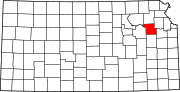 | |
| Unincorporated communities | ||
| Ghost towns | ||
| Townships | ||
| Footnotes | †This community is designated a Census-Designated Place (CDP) by the United States Census Bureau. ‡This community also has portions in an adjacent county or counties. | |