
Kjelfossen
| Kjelfossen | |
|---|---|
 Kjelfossen | |
 | |
| Location | Gudvangen, Norway |
| Coordinates | 60°52′29″N 06°51′43″E / 60.87472°N 6.86194°E |
| Type | Segmented |
| Total height | 755 m (2,477 ft) |
| Longest drop | 198 m (650 ft) |
| Watercourse | Kjelfossgrovi |
| World height ranking | 18 |
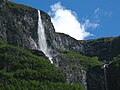
Kjelfossen (English: Kjell Falls) is one of the highest waterfalls in Norway. The falls are located near the village of Gudvangen in the municipality of Aurland in Sogn og Fjordane county. With a total fall height of 755 metres (2,477 ft), the waterfall is listed as the 18th tallest waterfall in the world. The tallest single drop is 149 metres (489 ft)[citation needed]. The height of the waterfall has never been accurately measured, so there are discrepancies in its actual height. Some sources list it as 840 metres (2,760 ft) tall.[1][2]
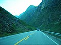
The largest of the three (the one on the left) is officially named Kjelfossen, but is also known as Stor Kjelfossen. The middle falls is known as Vetle Kjelfoss, and the one on the right (and the smallest by volume) is thought to be unnamed.[2] The falls are located just east of Gudvangen at the end of the Nærøyfjord. The falls can be seen from the ![]() E16 highway, just west of the entrance into the Gudvanga Tunnel. The falls are located about 18 kilometres (11 mi) west of Flåm and 27 kilometres (17 mi) west of Aurlandsvangen.
E16 highway, just west of the entrance into the Gudvanga Tunnel. The falls are located about 18 kilometres (11 mi) west of Flåm and 27 kilometres (17 mi) west of Aurlandsvangen.
Media gallery
-
 Part of the Kjelfossen
 -
 View of Kjelfossen
 -
 Kjelfossen
 -
 View from the highway


References
- ^ "Statistical Yearbook of Norway 2009". Statistics Norway.
- ^ a b "Kjelfossen". World Waterfall Database.
This Vestland location article is a stub. You can help Wikipedia by expanding it. |
This waterfall-related article is a stub. You can help Wikipedia by expanding it. |