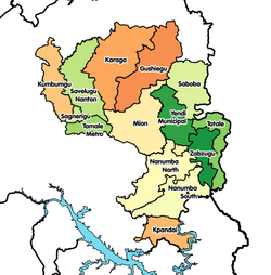
Kpandai District
Kpandai District | |
|---|---|
 Districts of Northern region | |
Kpandai District in Northern region | |
| Coordinates: 8°29′N 0°1′W / 8.483°N 0.017°W | |
| Region | Northern Region |
| Capital | Kpandai |
| Government | |
| • District executive | HON ATTA KOFI TATABLATA |
| Area | |
| • Total | 1,772 km2 (684 sq mi) |
| Population (2010) | |
| • Total | 108,816 |
| The population of the district according to 2010 population and housing census stands at 108,816 with 54,997 males and 53,819 females. | |
| Time zone | UTC+0 (Greenwich Mean Time) |
| • Summer (DST) | GMT |
| ISO 3166 code | GH-NP-KP |
The Kpandai District is one of twenty administrative districts in the Northern Region of Ghana.[1] The district shares boundaries with East Gonja to the west, Nanumba South to the north, Nkwanta North and Nkwanta South to the East and Krachi West to the south. Kpandai District's capital is the eponymous city of Kpandai. The district was created in 2008 by carving out an area of what was previously East Gonja District.[2][3]
The district is largely rural, with approximately 90% of the population engaged in local agriculture.[4] As of the 2010 census, the district population was 108,816 and included at least 24 different ethnic groups.[4]
Kpandai district was curved out of the East Gonja district on 29 February 2008 by an Act of Parliament through a Legislative Instrument (L.I) 1845 and is the highest Administrative and Political authority within its sphere of influence and jurisdiction. The President by an Executive Instrument (E.I) created 27 new Districts, 4 Municipalities, Upgraded 26 existing Districts and 2 existing Municipalities.
Sources
References
- ^ Northern » Kpandai
- ^ Northern region Archived 2013-10-29 at the Wayback Machine
- ^ Ghana Ministry of Food and Agriculture. "Kpandai District".
{{cite web}}: Cite has empty unknown parameter:|dead-url=(help) - ^ a b Ghana Statistical Service (2014). "2010 Population & Housing Census: Kpandai District Analytical Report" (PDF).
{{cite web}}: Cite has empty unknown parameter:|dead-url=(help)
8°29′N 0°1′W / 8.483°N 0.017°W


