Laba (river)
Appearance
This article has multiple issues. Please help improve it or discuss these issues on the talk page. (Learn how and when to remove these template messages)
|
| Laba River | |
|---|---|
 | |
 | |
| Physical characteristics | |
| Source | |
| • coordinates | 44°17′15″N 40°53′45″E / 44.28750°N 40.89583°E |
| Mouth | |
• location | Kuban River |
• coordinates | 45°11′14″N 39°41′29″E / 45.18722°N 39.69139°E |
| Length | 214 km (133 mi) |
| Basin size | 12,500 km2 (4,800 sq mi) |
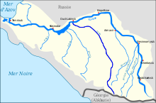
The Laba (Russian: Лаба Laba; Circassian: Лабэжъ Labez̄) is a river in Krasnodar Krai and Adygea of European Russia. It is a tributary of the Kuban River, which it joins at Ust-Labinsk. It is formed by the confluence of the Bolshaya Laba River and the Malaya Laba River (Малая Лаба Malaja Laba; Лабэжьый Labez̄yj). It is used for irrigation and log driving. It is also suitable for rafting.
External links
Wikimedia Commons has media related to Laba River.
