
Iberá Wetlands
| Iberá Wetlands Esteros del Iberá Yno'õ Y Vera | |
|---|---|
 Aerial view of the Iberá Provincial Reserve | |
| Map | |
 | |
| Geography | |
| Location | |
| Area | 20,000 km2 (7,700 sq mi) |
The Iberá Wetlands (Spanish: Esteros del Iberá, from Guaraní ý berá: "bright water") are a mix of swamps, bogs, stagnant lakes, lagoons, natural slough, and courses of water in the center and center-north of the province of Corrientes, Argentina.
Iberá is one of the most important freshwater reservoirs in South America and the second-largest wetland in the world after Pantanal in Brazil.[citation needed] It is of pluvial origin, with a total area of 15,000–20,000 km2 (5,800–7,700 sq mi).
Since 1982, part of the wetland is included within a provincial protected area, the Iberá Provincial Reserve, which comprises about 13,000 km2 (5,000 sq mi), the largest of such areas in Argentina. There are ongoing plans to further up its protection status to national park.
-
 Esteros del Iberá Marsh
 -
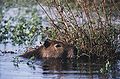 Capybara at Iberá
 -
 Esteros del Iberá Lagoon
 -
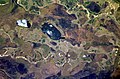 Some lakes in the Iberá Wetlands, reflecting sunlight

_Iber%C3%A1.jpg)


See also
[edit]References
[edit]External links
[edit]- Rewilding Ibera: Efforts made to save Argentina's wetlands. Al Jazeera Englisch, January 2021 (video, 4:25 mins)
![]() Media related to Esteros del Iberá at Wikimedia Commons
Media related to Esteros del Iberá at Wikimedia Commons
28°36′00″S 57°49′01″W / 28.600°S 57.817°W
This article about a place in Corrientes Province, Argentina is a stub. You can help Wikipedia by expanding it. |