
Lake Chelan
| Lake Chelan | |
|---|---|
| Location | Chelan County, Washington, USA |
| Coordinates | 47°50′28″N 120°02′47″W / 47.84111°N 120.04639°W |
| Primary inflows | Stehekin River |
| Primary outflows | Chelan River |
| Basin countries | United States |
| Max. length | 55 mi (89 km) |
| Surface area | 52.1 sq mi (135 km2) |
| Average depth | 474 ft (144 m) |
| Max. depth | 1,486 ft (453 m) |
| Water volume | 4.68 cu mi (19.5 km3) |
| Residence time | 10.6 years |
| Shore length1 | 109.2 mi (175.7 km) |
| Surface elevation | 1,098 ft (335 m) |
| Settlements | Chelan, Manson, Stehekin, Holden, Lucerne |
| References | [1][2] |
| 1 Shore length is not a well-defined measure. | |
Lake Chelan is a narrow, 55-mile-long lake in Chelan County, northern Washington state, U.S.[1] It is the largest natural lake in Washington state. The name Chelan is a Salish Indian word Tsi - Laan, meaning deep water.[3]
Fed by streams from the Cascade Range, Lake Chelan has maximum depth of 1,486 ft (453 m) (though some sources cite 1,420 feet[citation needed]), making it the third deepest lake in the country and the 25th deepest in the world. The surface of the lake is 1,098 feet (335 m) above sea level, while the average width of the lake is one mile.[1]
The city of Chelan sits at the southeast tip of the lake, where its water flows into the Chelan River through the hydroelectric Lake Chelan Dam. At the northwest end of the lake is the town of Stehekin, where the town's namesake river, the Stehekin River, flows into the lake. The Stehekin is the lake's largest inflow stream. Access to the far end of the lake is limited to boat, float plane, or hiking. Lake Chelan State Park lies along the southern shore of the lake, and can be accessed from the city of Chelan by road. The northern portion of the lake is protected by Lake Chelan National Recreation Area.
-
 Lake Chelan as seen from the southern shore off United States Highway 97. The word Chelan comes from the Indian word Tsi - Laan, which means "deep water."
 -
 View of Manson orchards from the south shore of Lake Chelan.
 -
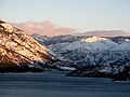 View uplake from the south shore of Lake Chelan.
 -
 View of Lake Chelan from Lakeshore trail, near Stehekin.
 -
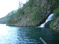 Domke Falls is the best known waterfall that drops into the lake.


See also
References
- ^ a b c "TMDL Case Study: Lake Chelan, Washington". EPA Number: 841F94001. Environmental Protection Agency. January 1994. Retrieved 2007-02-11.
{{cite web}}: Cite has empty unknown parameter:|coauthors=(help); horizontal tab character in|work=at position 12 (help) - ^ Kendra, Will (January 1987). "Morphometry of Lake Chelan". Ecology Report 87-1. Washington State Department of Ecology. Retrieved 2007-06-26.
{{cite web}}: Unknown parameter|coauthors=ignored (|author=suggested) (help) - ^ "Native American Legends" (PDF). USDA Forest Service - Pacific Northwest Region. Retrieved 2007-06-26.
External links
- National Parks Service Lake Chelan
- University of Washington Libraries Digital Collections – Lawrence Denny Lindsley Photographs Includes 66 images (ca. 1907–1950) of Lake Chelan and nearby settlements.
- Schoolbus plunges into Lake Chelan, killing 15 students and the driver, on November 26, 1945.
- Emily von Jentzen swims Lake Chelan