Landstuhl
This article needs additional citations for verification. (May 2008) |
Landstuhl | |
|---|---|
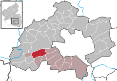
Location of Landstuhl within Kaiserslautern district  | |
| Coordinates: 49°24′44″N 07°34′20″E / 49.41222°N 7.57222°E | |
| Country | Germany |
| State | Rhineland-Palatinate |
| District | Kaiserslautern |
| Municipal assoc. | Landstuhl |
| Government | |
| • Mayor | Ralf Hersina |
| Area | |
| • Total | 15.34 km2 (5.92 sq mi) |
| Elevation | 248 m (814 ft) |
| Population (2022-12-31)[1] | |
| • Total | 8,336 |
| • Density | 540/km2 (1,400/sq mi) |
| Time zone | UTC+01:00 (CET) |
| • Summer (DST) | UTC+02:00 (CEST) |
| Postal codes | 66849 |
| Dialling codes | 06371 |
| Vehicle registration | KL |
| Website | www.landstuhl.de |
Landstuhl (German pronunciation: [ˈlantʃtuːl]) is a municipality of over 9,000 people in southwestern Germany. It is part of the district of Kaiserslautern, in the Rhineland-Palatinate, Germany, and is home to the Sickinger Schloss, a small castle. It is situated on the north-western edge of the Palatinate forest, approx. 10 km west of Kaiserslautern.
The earliest traces of human settlement in Landstuhl date from about 500 BCE; the “Heidenfels” (i.e. "heathen rock") from the Celtic period was a holy site even until Roman times, and a Roman settlement dates from the 1st Century CE.
The place is said[note 1] to have been called, late in the first millennium, Nannenstuhl, with the sense "seat of Nanthari"[2] (who was also called "Nanno"); perhaps once memory of Nathari was centuries dead, the reference to him mutated into "Land", with "Landstuhl" construable as "seat [for governing] [the settlement's surrounding] territory".
In the 15th Century, the noble family of Sickingen assumed responsibility for Landstuhl and the surrounding area.[3] The most famous member of this family was Franz von Sickingen. Franz von Sickingen built his castle in Landstuhl – Burg Nanstein (the most visible landmark in Landstuhl and the surrounding area) - into a dominating fortress that was supplemented by Burg Landstuhl. From this base he moved to expand his domains by conquering other parts of southwestern Germany.
After several defeats, Sickingen withdrew to his castle and was besieged by Richard Greiffenklau, Archbishop of Trier, and the Counts of the Rhine and Hesse. During the bombardment of Nanstein, Franz von Sickingen was killed. The castle was later expanded by Sickingen’s descendants, but it was heavily damaged by the French in 1689.
Landstuhl is the seat of the Verbandsgemeinde ("collective municipality") Landstuhl.
Landstuhl is the location of Landstuhl Regional Medical Center, a major U.S. Army hospital,[3] consequently there are many Americans living in the area. Landstuhl is also known for being the birthplace of these Americans:
- Aaron Altherr, outfielder for the Philadelphia Phillies, holds dual citizenship
- Shawn Bradley, retired basketball player, holds dual American and German citizenship
- LeVar Burton, actor, best known for roles in Star Trek: The Next Generation and Roots, and as the host of Reading Rainbow.
- DRAM (rapper), Musician, Later raised in Hampton, Virginia, U.S.
- David Rouzer, member of the United States House of Representatives
- Rob Thomas, lead singer of Matchbox Twenty
- Reggie Williams, former wide receiver for the Jacksonville Jaguars
Notes
- ^ [Anonymous], "Village names related to the surname Nendel", asserts -- citing Hermann Schreibmüller's Die Ahnen Kaiser Konrads II. und Bischof Brunos von Würzburg -- that "The village Landstuhl in the Palatinate was called Nannenstuhl in the 8th century...."
(Availability of the H.S. work seems limited - - - -.)
References
- ^ "Bevölkerungsstand 2022, Kreise, Gemeinden, Verbandsgemeinden" (PDF) (in German). Statistisches Landesamt Rheinland-Pfalz. 2023.
- ^ "Nantharius Graf im Worms- und Nahegau -- † nach 870"
- ^ a b Public Affairs Office. "Fact Sheet – LRMC History Landstuhl Regional Medical Center" (PDF). Archived from the original (PDF) on 17 April 2012. Retrieved 16 June 2012.
{{cite web}}: Unknown parameter|deadurl=ignored (|url-status=suggested) (help)


