
Lanham, Kansas and Nebraska
Lanham, Kansas and Nebraska | |
|---|---|
 | |
| Coordinates: 40°13′06″N 96°52′33″W / 40.21833°N 96.87583°W | |
| Country | United States |
| State | Kansas, Nebraska |
| County KS NE | Washington, Kansas, Gage, Nebraska |
| Elevation | 1,398 ft (426 m) |
| Time zone | UTC-6 (Central (CST)) |
| • Summer (DST) | UTC-5 (CDT) |
| ZIP code | 66945, 68415 |
| FIPS code | 20-38625, 31-38625 |
| GNIS feature ID | 829069 |
Lanham is an unincorporated community in both Washington County, Kansas and Gage County, Nebraska in the United States.[1] It is located along State Line Road just west of K-148/Nebraska Highway 112.[citation needed] Its main street forms the state line.[2]
History
Lanham was named for a railroad official.[3] A post office was opened in Lanham (on the Kansas side[3]) in 1914, and remained in operation until it was discontinued in 1923.[4]
References
- ^ U.S. Geological Survey Geographic Names Information System: Lanham, Kansas and Nebraska
- ^ Brackman, Barbara (1997). Kansas Trivia. Thomas Nelson Inc. p. 10. ISBN 9781418553814.
- ^ a b Fitzpatrick, Lillian L. (1960). Nebraska Place-Names. University of Nebraska Press. p. 65. ISBN 0803250606.
- ^ "Kansas Post Offices, 1828-1961". Kansas Historical Society. Archived from the original on 9 October 2013. Retrieved 27 June 2014.
{{cite web}}: Unknown parameter|deadurl=ignored (|url-status=suggested) (help)
External links
Municipalities and communities of Washington County, Kansas, United States | ||
|---|---|---|
| Cities | 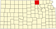 | |
| Unincorporated community | ||
| Ghost town | ||
| Townships |
| |
| Footnotes | ‡This community also has portions in an adjacent county or counties. | |
Municipalities and communities of Gage County, Nebraska, United States | ||
|---|---|---|
| Cities |  | |
| Villages | ||
| Townships | ||
| CDP | ||
| Unincorporated communities | ||
| Footnotes | ‡This populated place also has portions in an adjacent state | |
This Kansas state location article is a stub. You can help Wikipedia by expanding it. |
This Nebraska state location article is a stub. You can help Wikipedia by expanding it. |