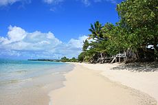
Lano, Samoa
Appearance
This article needs additional citations for verification. (September 2014) |

Lano is a village on the north east coast of Savai'i island in Samoa.[1] The village is part of the electoral constituency (Faipule District) Fa'asaleleaga IV which is within the larger political district (Itumalo) of Fa'asaleleaga.
The population is 721 (2006 Census).[2]
The village has white sandy beaches by the main island road and there are beach fale for visitors and tourists and reef breaks for surfing.
References
- ^ "Samoa Territorial Constituencies Act 1963". Pacific Islands Legal Information Institute. Archived from the original on 5 June 2011. Retrieved 19 December 2009.
{{cite web}}: Unknown parameter|deadurl=ignored (|url-status=suggested) (help) - ^ "Population and Housing Census Report 2006" (PDF). Samoa Bureau of Statistics. July 2008. Archived from the original (PDF) on 21 July 2011. Retrieved 19 December 2009.
{{cite web}}: Unknown parameter|deadurl=ignored (|url-status=suggested) (help)
13°36′47″S 172°12′04″W / 13.613°S 172.201°W

